Preliminary Environmental Information Report: Non-Technical Summary
1. Introduction
This document is the Non-Technical Summary (NTS) of the Preliminary Environmental Information Report (PEIR) for the proposed Dogger Bank D Offshore Wind Farm Project (referred to as the 'Project' or 'DBD' in this document).
This NTS has been produced to support public and stakeholder consultation by providing an accessible, high-level overview of the Project, including the site selection process and engineering design development. Written in non-technical language, it provides a summary of the preliminary environmental information and explains the potential environmental effects - or 'likely significant effects' as termed in the PEIR - throughout all stages of the Project, from construction to decommissioning.
For full details of the potential environmental effects associated with the Project, the reader is directed to the PEIR chapters set out in Volume 1.
A complete listing of published PEIR documents is contained in the Guide to the PEIR and the Document Register. All PEIR documents can be accessed below:
Dogger Bank D (DBD) is the fourth phase of the Dogger Bank Wind Farm, the world’s largest offshore wind farm in construction. By harnessing the power of offshore wind, the Project would be capable of exporting up to 1.5GW of renewable electricity, thereby supporting the decarbonisation of the UK energy system as well as contributing to UK energy security.
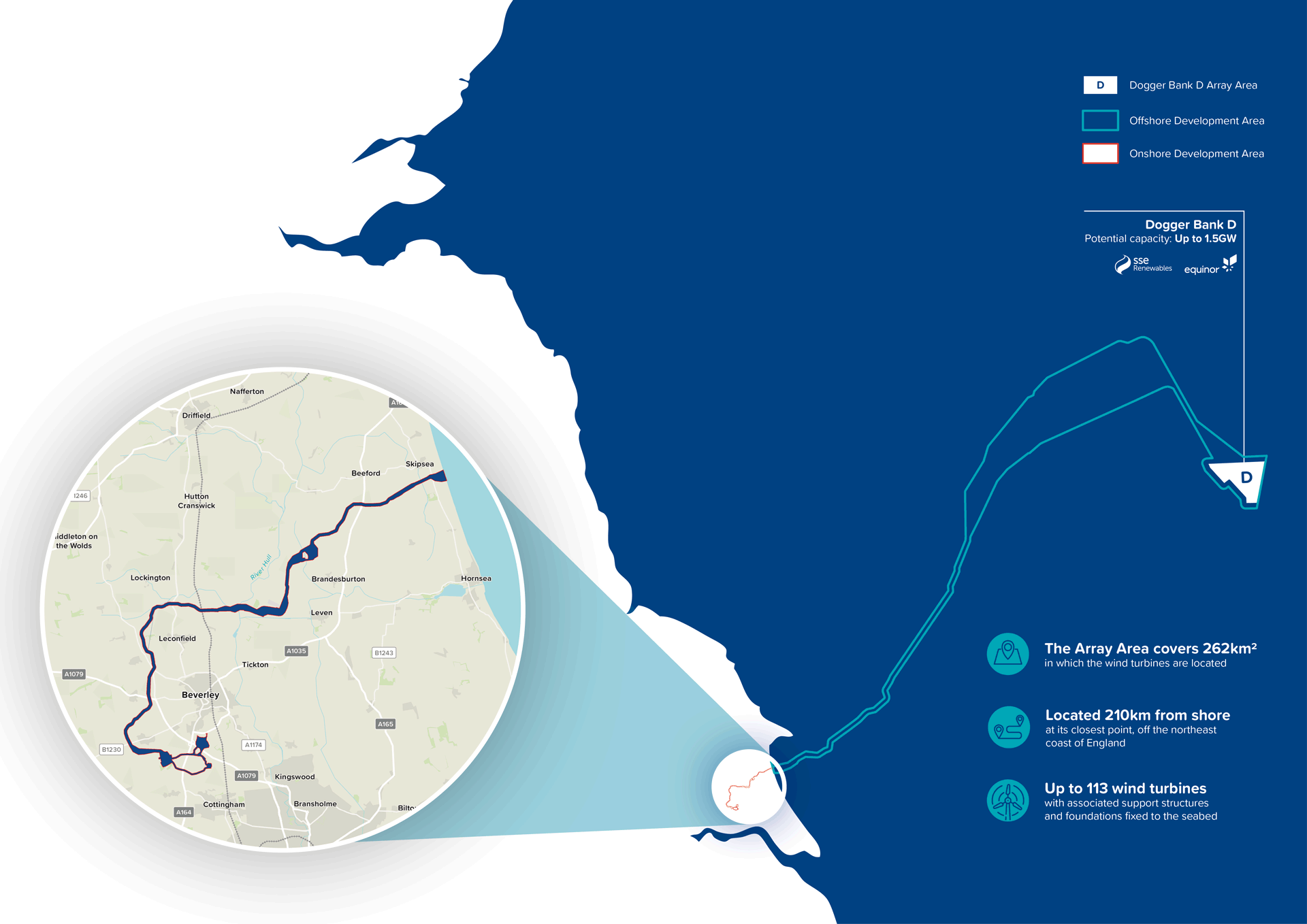
The Project’s offshore array area is located in the Dogger Bank region of the southern North Sea, approximately 210km off the Yorkshire coast at its nearest point. The array area comprises a maximum of 113 offshore wind turbines and up to two offshore platform(s). The turbines will be connected to the offshore platforms via subsea inter-array cables and from there the offshore export cables will transfer the electricity to shore.
The Project’s offshore export cables will make landfall at a location south-east of Skipsea in the East Riding of Yorkshire. Here they will be joined to onshore export cables which will run approximately 50km, through a predominantly agricultural landscape to the onshore converter station (OCS) zone. From the OCS zone, the cables will run to the grid connection point at the proposed National Grid Birkhill Wood Substation located south of Beverley. Note Birkhill Wood Substation is being developed by National Grid Electricity Transmission and is not part of the Project’s proposals.
The OCS zone will contain the onshore converter station which will convert electricity for the grid connection. Energy Storage and Balancing Infrastructure (ESBI) is also proposed in this zone. The ESBI would allow the temporary storage of excess energy from the Project, which can be released to the national network when it’s needed. To maintain flexibility at this stage two OCS Zones are included at PEIR (referred to in the PEIR documents as Zone 4 and Zone 8).
Figure 1 Offshore and onshore areas covered by DBD (click to enlarge)
1.2 The Team Behind DBD
DBD is being developed as a 50 / 50 joint venture between SSE Renewables and Equinor, two of the world’s leading companies in the development and operation of offshore wind energy.
SSE Renewables is leading the development of the Project on behalf of the joint venture, with both companies having been involved in designing and securing planning consent for Dogger Bank Wind Farm, the world’s largest offshore wind farm in construction.
Climate change is driven by greenhouse gas emissions, which have increased significantly over the past 200 years. These emissions cause global temperatures to rise, leading to negative impacts on weather patterns, ecosystems, and human health.
The UK has committed to reducing all greenhouse gas emissions to net-zero by 2050. National policy and legislation, influenced by international drivers, highlight the need for renewable energy infrastructure to play a part in combatting climate change.
In December 2024, the UK Government published the “Clean Power 2030 Action Plan,” aiming to deliver a secure, low-carbon, and low-cost electricity supply for consumers and achieve net zero carbon emissions by 2050. The plan emphasises the need for rapid expansion in low-carbon electricity generation capacity and outlines actions to meet these goals within the required timeframes. The action plan includes a Clean Power Capacity Range for operational offshore wind of 43-50GW by 2030 and a Capacity Range of 72-89GW by 2035.
DBD will contribute up to 1.5GW to the UK’s decarbonisation targets and global commitments to mitigating climate change, and, once fully operational, will be capable of powering up to 2.5 million UK homes per year*.
As a renewable energy project, DBD will contribute to the UK’s renewable energy and climate targets and contribute to the following Government aims:
Reducing GHG emissions;
Decarbonisation of the power sector;
Increasing the security of energy supply;
Increasing energy affordability; and
Providing economic opportunities.
DBD will help to improve the UK’s energy security by generating low-carbon, renewable, lower cost electricity and thereby reduce reliance on imported oil and gas. Generation of British-based renewable energy, such as offshore wind, reduces the UK’s vulnerability to volatility in world energy market prices, political pressure, physical supply disruptions and the knock-on effects of supply challenges in other countries.
*Up to 2.5 million homes powered per annum based on mean domestic annual electricity consumption in Great Britain 2023, 3,301kWh per household; DESNZ 2024, assumed offshore wind load factor of 62.3%, DESNZ 2024 (Contracts for Difference Standard Terms Notice), and projected installed capacity of up to 1.5GW.
The Project must comply with various international, national and local legislation, policies and plans.
As DBD will generate more than 100 megawatts (MW) of renewable energy, it is classed as a Nationally Significant Infrastructure Project (NSIP). This means the Project must obtain a Development Consent Order (DCO) from the Secretary of State under the Planning Act 2008. The Planning Act 2008 and the Infrastructure Planning (Environmental Impact Assessment) Regulations 2017 form the legal basis for DCO applications for NSIP such as DBD. The DCO application will be accompanied by an Environmental Statement (ES) (in accordance with The EIA Regulations 2017).
National Policy Statements (NPS) set out specific policy content in relation to NSIP. The UK’s commitment to renewable energy has been captured in the following NPS, which are relevant to DBD:
EN-1 for Overarching Energy;
EN-3 for Renewable Energy Infrastructure; and
EN-5 for Electricity Networks Infrastructure.
The National Planning Policy Framework (NPPF) consolidates various national planning documents to provide a framework for planning decision making in England, setting out how the Government’s economic, environmental and social planning policies for England should be applied.
The NPPF helps inform decision making on planning applications and includes policies and principles with regard to the protection and conservation of the natural and built environment as well as sustainable growth and development which are relevant to DBD.
For the offshore development area, the relevant Marine Plans considered include the East Inshore and East Offshore Marine Plans, as well as the North East Inshore and Offshore Marine Plan, under the overarching UK Marine Policy Statement. These are considered in the offshore PEIR Chapters.
The onshore development area falls under East Riding of Yorkshire Council’s jurisdiction and the relevant local policies have been identified and considered in the onshore PEIR Chapters.
Further details on relevant policy and legislation are provided in:
The Off shore Development Area covers all the elements of the Project seaward of Mean High Water Springs (MHWS). The Onshore Development Area includes the elements of the Project landward of Mean Low Water Springs (MLWS). An overview of the off shore and onshore development areas of the Project are set out in Figure 2.
2.1.1 Offshore Components
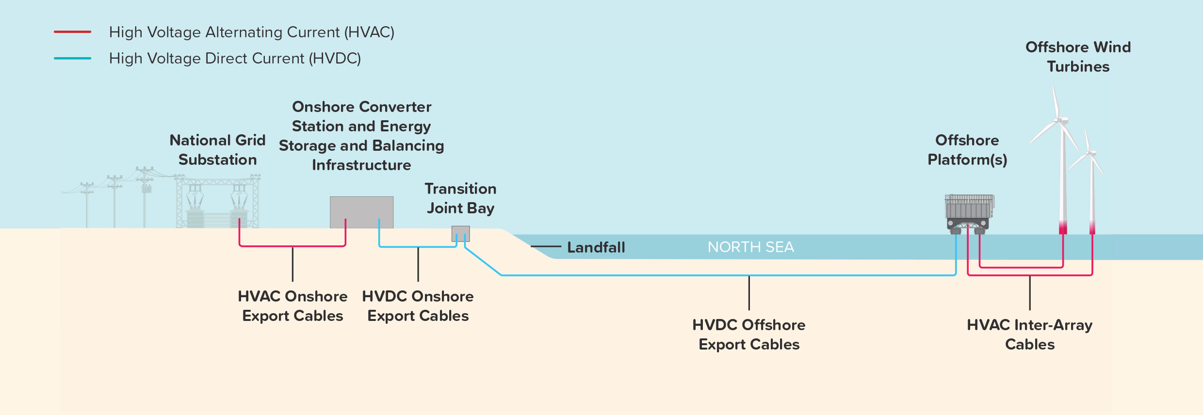
The Array Area covers 262km2 and is located 210km from shore at its closest point. The area will include up to 113 wind turbines which generate electricity. Subsea inter-array cables will connect the wind turbines with up to two off shore platform(s), which collect the electricity generated and facilitate onward transmission. Foundations are used to secure the wind turbines and off shore platform(s) to the seabed.
Figure 2 The Development Area covered by DBD (click to enlarge)
Figure 3 Overview of the Project’s infrastructure and connection to the UK power grid (click to enlarge)
Wind Turbines and Foundations
The total number of wind turbines that would be installed within the Array Area is dependent on the size and generating capabilities of the wind turbine model selected. The fi nal number will be determined postconsent, but it will not exceed 113.
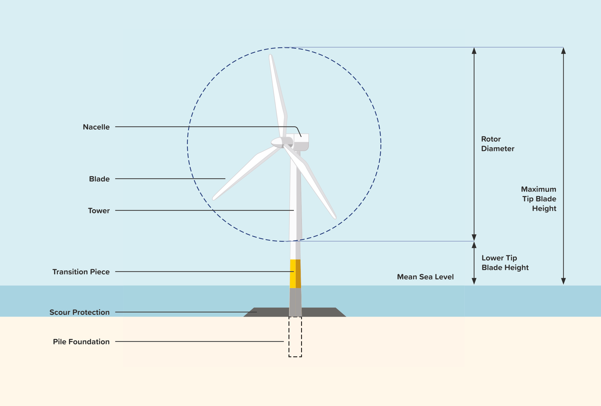
Wind turbines will have three turbine blades, a hub (where all blades meet in the middle) connected to a nacelle (which houses the electrical generator and ancillary equipment), and a tubular steel tower which will be fi xed to the seabed via a foundation. The hub would be up to 201.5m from sea level, and the blade tips would be up to a maximum of 370m, and a minimum of 28m, above Lowest Astronomical Tide. A typical turbine is shown in Figure 4.
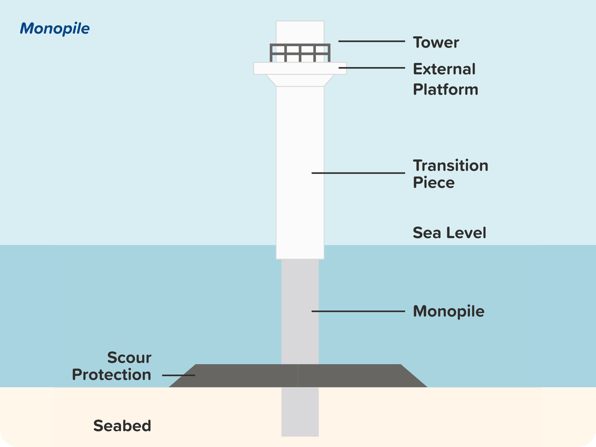
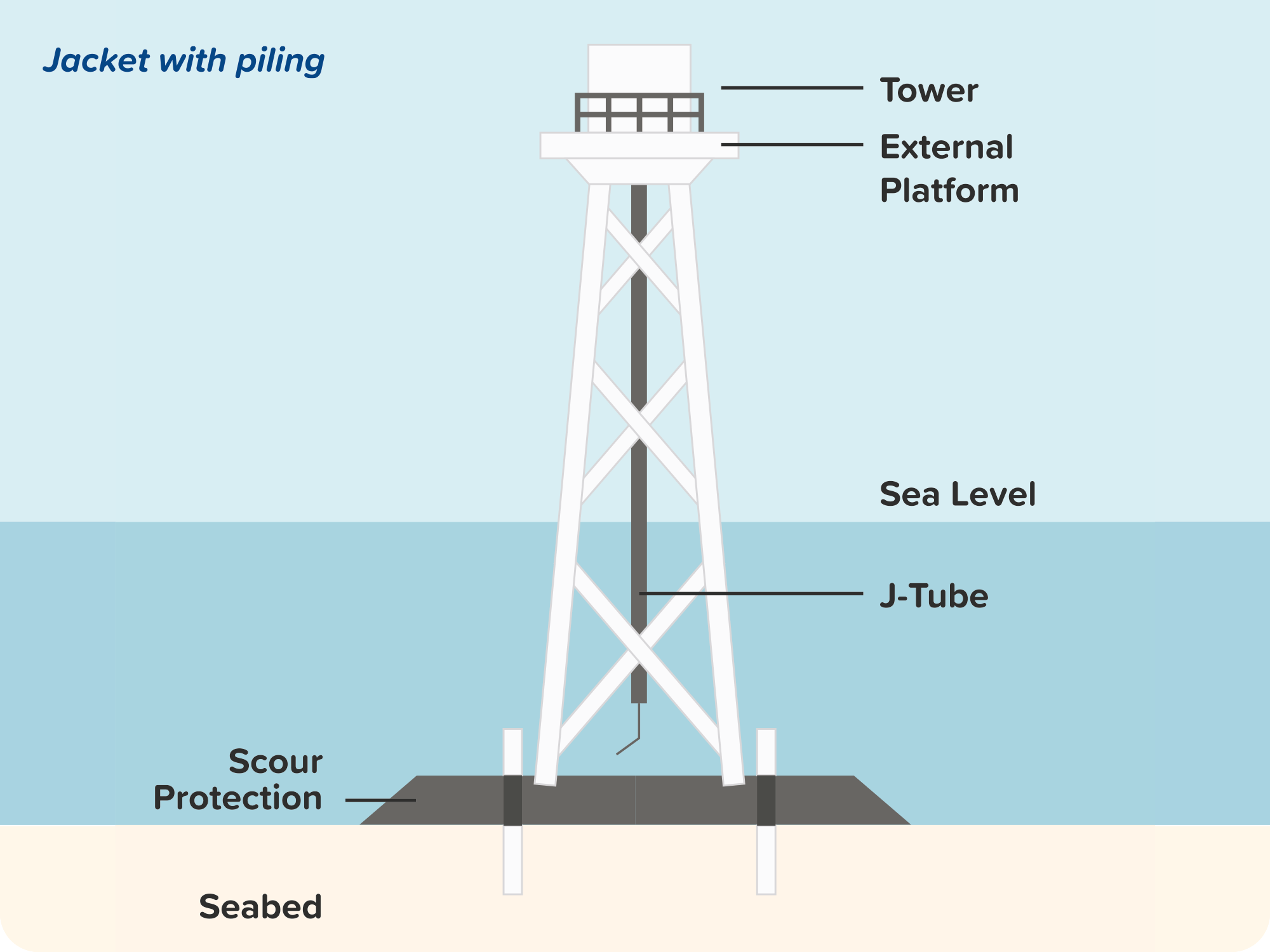
There are several types of wind turbine foundations. The options being considered for this Project are:
Monopiles – a singular tubular piece, formed of a number of steel cylinders welded together and driven into the seabed;
Piled jackets – tubular steel pieces welded into a lattice that are fastened to the seabed using long rods, known as pin-piles, that are piled through the legs; and
Suction bucket jackets – a steel lattice structure that is secured to the seabed via suction buckets creating negative pressure.
Typical foundation structures are shown in Figure 5.
Figure 4 Indicative wind turbine schematic (click to enlarge)
Figure 5 Indicative foundation structures (click to enlarge)
Offshore Platform(s)
The offshore platform(s) are structures that collect the electricity from the turbines and house electrical equipment to maximise efficiency of transmission by changing the voltage and the type of current. The Project will include up to two offshore platforms.
These offshore platform(s) would be secured to the seabed, using either the foundation types described or one of two additional options outlined below:
Gravity base foundation – concrete or steel structures that are transported to site by barge and then deposited on the seabed; and
Arup Concept Elevating Platform – a selfinstalling fixed design that comprises a barge deck, a gravity steel base, tubular or lattice legs and a jacking system.
Inter-array and Export Cables
Subsea cables (inter-array and offshore export cables) are required to transmit the electricity generated by the wind turbines. Inter-array cables connect the turbines to the offshore platform(s) and up to two offshore export cables connect the offshore platform(s) to landfall. The offshore export cables include one fibre optic cable which is used for monitoring the condition of the cables. Subsea cables will be buried beneath the seabed wherever possible to a target depth of 3.5m. Where burial is not possible, cable protection will be installed to minimise risk of snagging and other hazards.
Offshore Export Cable Corridor
The offshore Export Cable Corridor is the area in which the subsea offshore export cables will be located.
2.1.2 Onshore Components
Landfall
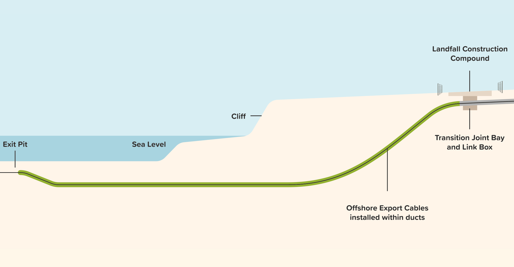
The landfall is located south-east of Skipsea. This is the point on the coastline where the offshore export cables are brought ashore to connect to the onshore export cables for onward transmission. At the shoreline, the ducts for the offshore export cables will be installed under the beach and emerge in an inland area on the clifftop. A trenchless technique will be used for the landfall duct installation to minimise environmental impact, reduce disruption to local communities and keep the beach accessible.
The offshore export cables will be jointed to the onshore export cables in an underground concrete structure known as a Transition Joint Bay (TJB). A smaller underground concrete enclosure known as a link box will also be installed adjacent to the TJB to allow access for cable joints inspections and maintenance during operation. The underground link box will be installed with a manhole cover at ground level and may be marked / protected by bollards, fences or similar equipment. Construction works at the landfall will be undertaken within a landfall construction compound.
Figure 6 shows an indicative cross-section of a trenchless installation technique at landfall.
Figure 6 Indicative cross-section of landfall trenchless installation works (click to enlarge)
Onshore Export Cables
The onshore Export Cable Corridor (ECC) is the area in which the buried onshore export cables will be located and is approximately 55km long. The onshore ECC extends from the landfall to the Onshore Converter Station (OCS) zone and continues onwards to the grid connection point at Birkhill Wood Substation (a separate project developed by National Grid Electricity Transmission). The cable corridor presented at this stage is approximately 200m wide, though some sections may be slightly wider or narrower to account for specific environmental, land or engineering constraints. The corridor width will be further refined and presented within the Environmental Statement (ES). The final corridor width will be refined during the detailed design stage post-consent, and the permanent infrastructure will only occupy part of the corridor.
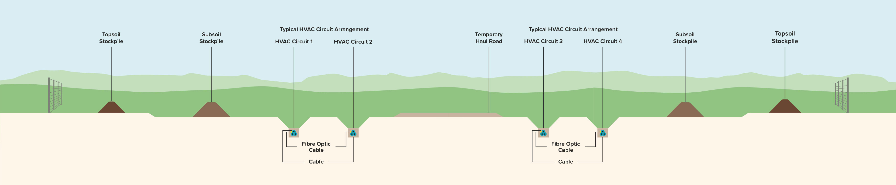
Two types of onshore export cables will be needed for electricity transmission. High Voltage Direct Current (HVDC) export cables will be installed from the landfall to the OCS zone, and High Voltage Alternating Current (HVAC) export cables will be installed from the OCS zone to Birkhill Wood Substation. Fibre optic cables will also be installed to allow communications between infrastructure components during operation.
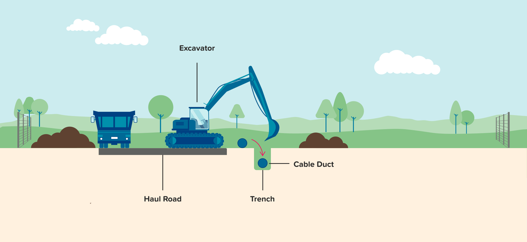
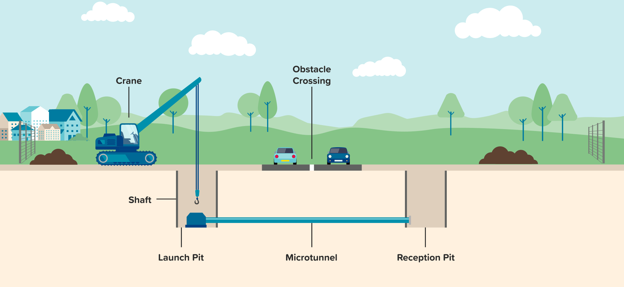
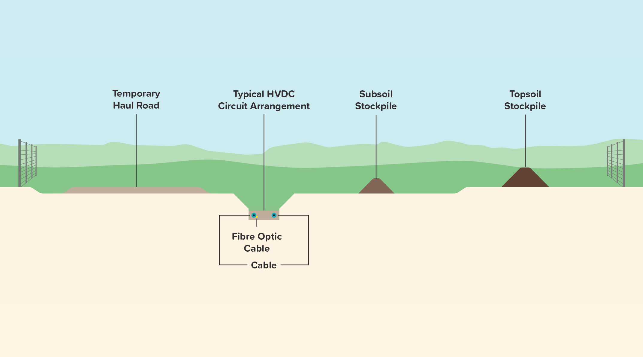
The onshore export cables will be buried along the entire length of the onshore ECC. Cables will be installed using mainly open-cut trenching techniques where trenches are dug, cable ducts are placed inside, and then covered with backfilled soil, as shown in Figure 7. Where open cut trenching is not suitable due to, for example, the presence of infrastructure and other constraints at the surface, a trenchless installation technique will be used. These techniques involve drilling a hole underground between an entry and exit pit to install cable ducts, avoiding interactions at the surface.
Figures 8 and 9 show two indicative trenchless installation techniques.
Note that Birkhill Wood Substation is being developed by National Grid Electricity Transmission and does not form part of the Project’s proposals.
Figure 7 Open cut installation technique (click to enlarge)
Figure 8 Horizontal directional drilling installation (click to enlarge)
Figure 9 Microtunnelling installation technique (click to enlarge)
Alongside the onshore export cables, underground concrete structures known as jointing bays will be installed at regular intervals to connect sections of onshore export cables together. Adjacent to the jointing bays, link boxes will be installed to allow for cable joints inspection and monitoring during operation. Link boxes will either be underground concrete enclosures with a manhole cover at ground level or, above-ground metal or plastic cabinets. Link boxes may be marked / protected by bollards, fences or similar equipment.
Construction along the onshore ECC will be undertaken within a construction corridor. This corridor will consist of the cable trenches, working areas for jointing bays and link boxes, haul roads, soil storage areas, temporary construction compounds and other temporary infrastructure such as drainage. The width of the construction corridor will typically be 32m for HVDC export cables and 55m for HVAC export cables, increasing to 50m and 60m respectively at trenchless crossing locations. The construction corridor will accommodate up to two trenches for the HVDC export cables and up to four trenches for the HVAC export cables shown in Figures 10 and 11.
Three types of temporary construction compounds will be required along the onshore ECC:
Main construction compounds – primary compounds located at strategic locations along the corridor;
Intermediate construction compounds – smaller compounds located between the main construction compounds; and
Trenchless installation compounds – smaller compounds located at the entry and exit pits of trenchless crossing locations.
Construction along the onshore ECC will be segmented into corridor sections, with works undertaken simultaneously in multiple sections. Once the cables are installed within each section, land within the onshore ECC will be reinstated. Reinstatement will involve removing temporary construction compounds, haul roads and other temporary infrastructure, putting back stored soil and returning the land to its pre-construction conditions as far as practicable.
Figure 10 Indicative cross-section of temporary construction corridor for HVDC Export Cables (click to enlarge)
South of Walkington, the onshore ECC splits into two possible cable corridor sections to allow flexibility for routeing the onshore export cables into and out of the two OCS zones under consideration. The corridor section taken forward to development will depend on which OCS zone is selected.
Post-construction, an operational easement will be in place along the installed onshore export cables. The easement will be approximately 20m for HVDC export cables and 25m for HVAC export cables, which may widen at trenchless crossing locations. Ground-penetrating activities will be restricted within the easement to protect buried infrastructure, but normal agricultural activities are permitted. Small marker posts will be displayed along the operational easement to mark the location of the installed onshore export cables.
Figure 11 Indicative cross-section of temporary construction corridor for HVAC Export Cables (click to enlarge)
Onshore Converter Station (OCS) Zone
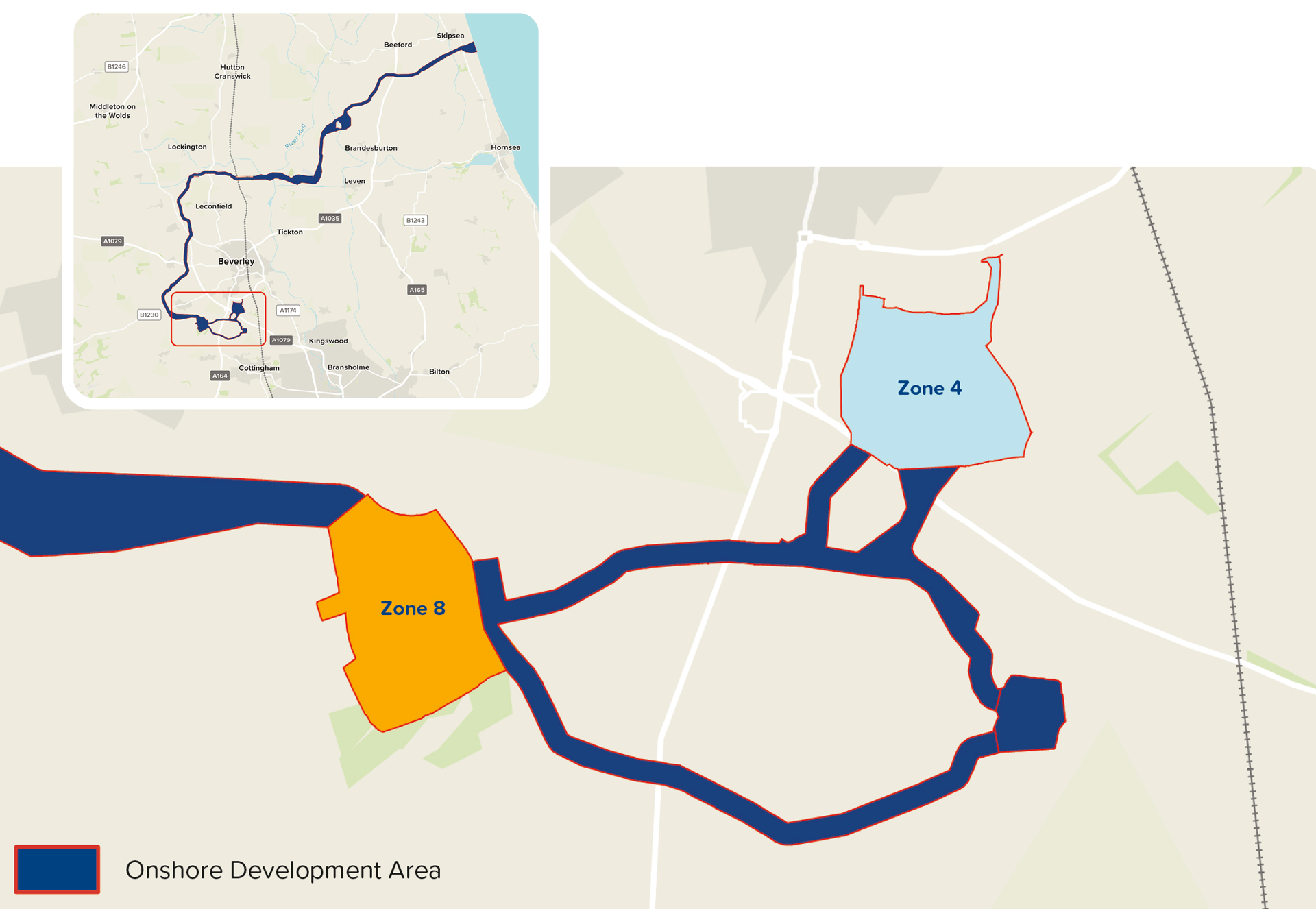
The OCS zone will contain the OCS and ESBI. Two zones remain under consideration and are presented at PEIR (see Figure 12):
Zone 4 – this is located on land south of Beverley at the junction between Beverley Road (A164) and Beverley Bypass (A1079); and
Zone 8 – this is located on land west of Bentley and Beverley Road (A164).
The OCS will comprise a fenced compound containing electrical equipment required to stabilise and convert electricity generated by the wind turbines into a suitable voltage for grid connection. The OCS will include buildings such as a valve hall and smaller service and storage buildings and outdoor equipment such as areas for transformers and reactors. The tallest building will be up to 25m, and the tallest outdoor equipment will be up to 30m.
Figure 12 Location of OCS Zone (click to enlarge)
2.2 Indicative Construction Programme
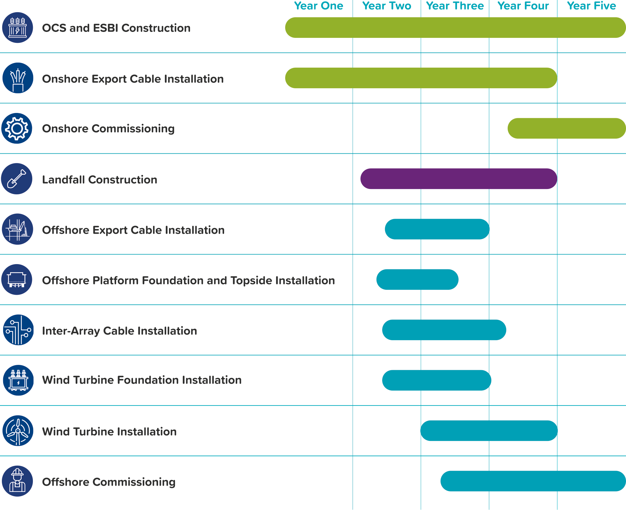
If the DCO is granted in 2028, construction could begin in 2029. The entire construction process is estimated to take approximately five years. The wind farm is expected to be fully operational by mid-2030s.
Figure 13 outlines the key stages of construction activities in an indicative programme. This is subject to change depending on factors such as commercial, consenting, procurement and construction considerations.
Construction will commence onshore with the construction of the OCS and ESBI and installation of onshore export cables, jointing bays and link boxes along the onshore
ECC undertaken in parallel. At the landfall, the TJB and cable ducts will be installed to allow the pull-in of offshore export cables ashore for jointing with the onshore export cables. Offshore construction will start with installation of the offshore platform(s), followed by installation of the inter-array and offshore export cables and wind turbines.
Following the completion of construction activities, commissioning of the installed infrastructure will take place ahead of first power.
Figure 13 Indicative construction programme
2.3 Operation and Maintenance
Following construction, the Project will enter the operation and maintenance (O&M) phase which is expected to last 35 years.
Offshore, two types of O&M activities will be required:
Preventative maintenance, such as planned servicing of wind turbines, offshore platform(s) and foundations, and surveys; and
Corrective maintenance, such as repairs, replacements, and remedial works on wind turbines, offshore platform(s), foundations, scour protection, and cables.
Onshore, O&M activities will primarily involve routine inspections of onshore infrastructure components and periodic testing and maintenance works. Unplanned maintenance works may also be required such as repairing faults along the installed onshore export cables. Replacement of components for the OCS and ESBI will be undertaken as required such as replacing battery units. The OCS and ESBI will be unmanned with no permanent on-site personnel presence.
2.4 Decommissioning
At the end of the Project’s O&M phase, the Project will enter the decommissioning phase. The final decommissioning strategy of the Project’s infrastructure will be determined based on current regulatory requirements and industry best practice at the time of decommissioning. Decommissioning activities are expected to be similar in nature to the construction process, but in reverse.
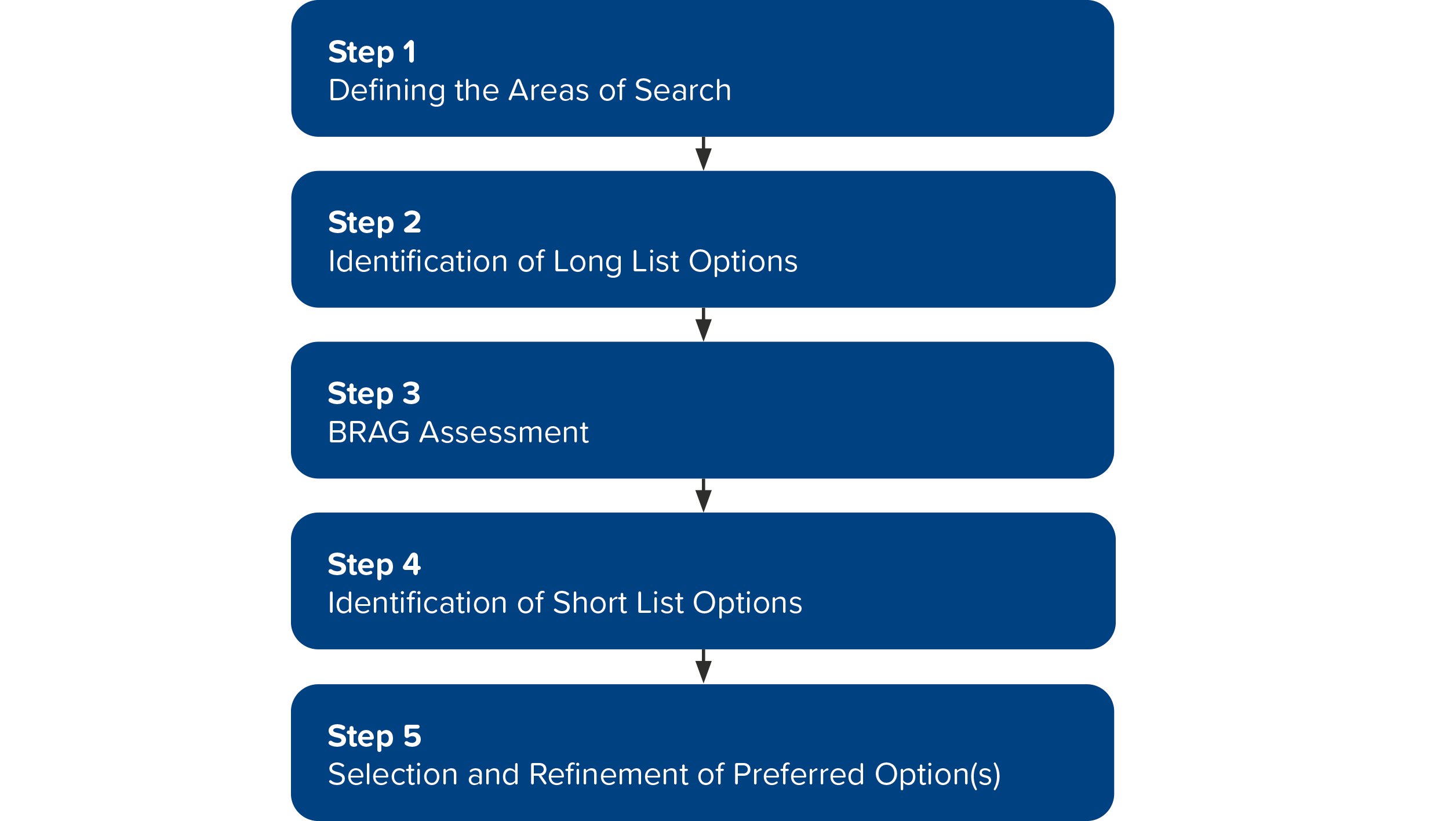
3. Site Selection and Consideration of Alternatives
The site selection process and consideration of alternatives is a key part of the Environmental Impact Assessment (EIA).
Site selection is an iterative process which has been guided by engineering, environmental and land considerations as well as through the engagement with the local community and statutory bodies.
The key steps of the site selection process are shown below. Although presented as a staged approach, site selection is an ongoing process, with steps often occurring in parallel or being revisited as new information comes in.
Site selection began with the identification of the array area which originally formed part of the Dogger Bank C phase of the Dogger Bank Wind Farm. Technological advancements meant that fewer wind turbines were required to generate the desired capacity for Dogger Bank C. As such, the eastern half of the Dogger Bank C array was not utilised and was identified for a fourth phase of the Dogger Bank Wind Farm.
Following this, National Energy System Operator undertook a strategic review of the UK’s framework for delivering its future energy system, which included Dogger Bank D. As a result of this review, a direct connection into the grid connection point at Birkhill Wood Substation was identified as the optimal design for the Project.
Using the Array Area and Birkhill Wood Substation as fixed end-points for the site selection process, a range of core principles were established to guide site selection for the Project’s different infrastructure components. These principles were based on best practice guidance as well as professional judgement, taking into account engineering feasibility, environmental sensitivities, land use, consenting risks, economic considerations, and stakeholder feedback.
To support site selection, the Project applied a Black-Red- Amber-Green assessment to evaluate each option across a range of topics, using the following criteria:
Black - Potential impediment to development with respect to environment or engineering risks;
Red - High environment or engineering risk to development;
Amber - Medium environment or engineering risk to development; and
Green - Low environment or engineering risk to development.
Through the use of the site selection principles and consideration of alternatives, the avoidance and minimisation of impacts on the environment and communities have been embedded into the Project. Further refinement will be undertaken through the EIA process, alongside considerations of additional engineering, environmental, land, economic and stakeholder information, leading up to the preparation of the DCO application submission.
The Project is classed as a NSIP and therefore an EIA is required to assess and inform decision-makers of the likely significant environmental effects of the Project.
4.1 Project Design Envelope
The PEIR assessments are based on a flexible approach called the ‘design envelope’ also known as the ‘Rochdale Envelope’. This allows for changes in certain design details, especially offshore, that are not yet decided such as the number and size of turbines, foundation types, or an exact route of the underground onshore cables. For the purposes of the EIA, a range of possibilities are considered to identify a ‘realistic worst-case scenario’ (the option with the greatest potential impact). The assessment then focuses on this scenario to make sure all possible effects are properly considered. The realistic worst-case scenario differs from topic to topic depending on the environmental factor being assessed.
Following PEIR publication, the Project Design Envelope will be further refined and confirmed in the ES. 'Post-consent' detailed design of the Project will be developed within the consented envelope prior to construction.
4.2 Environmental Impact Assessment
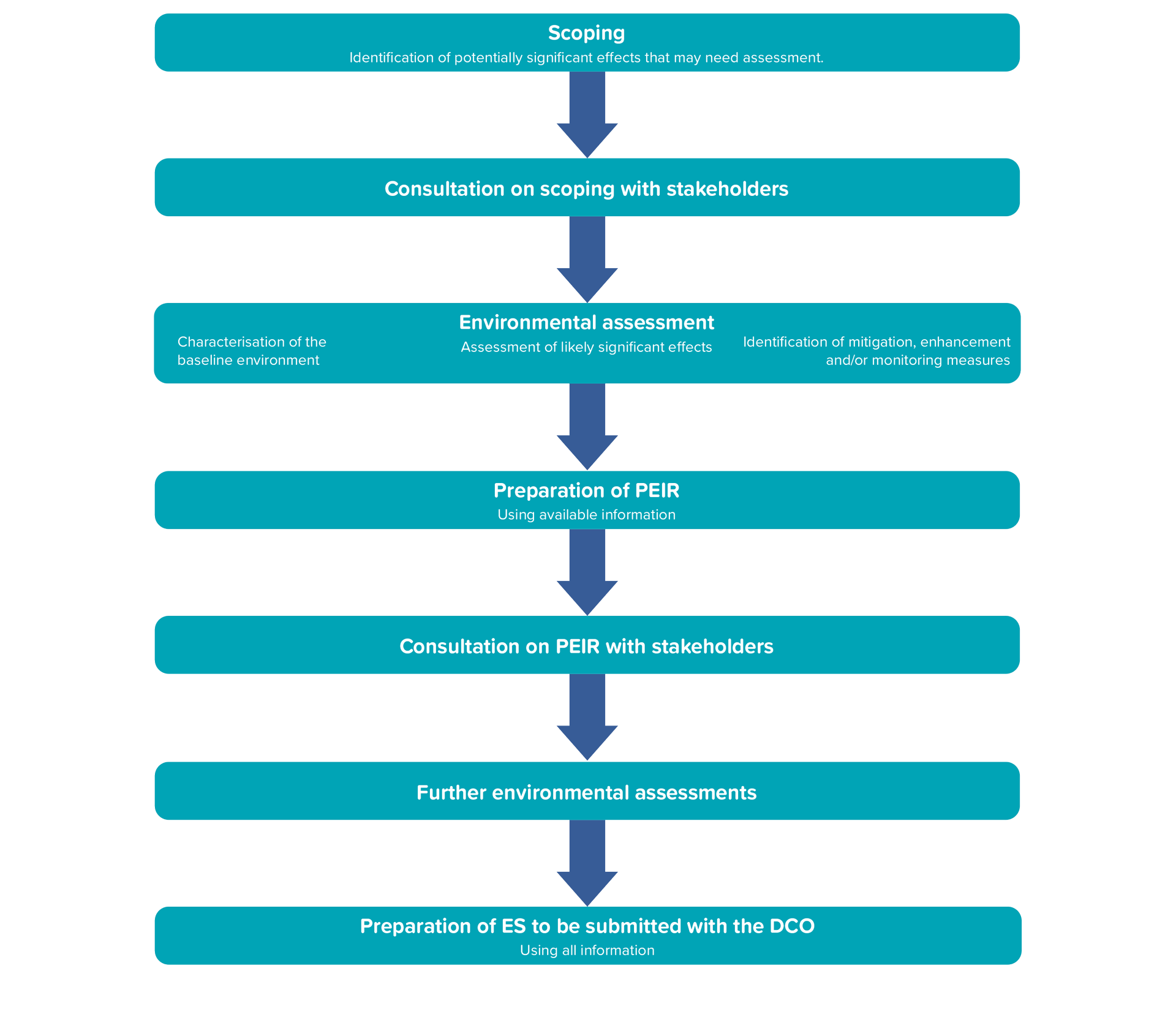
The EIA covers offshore, onshore, and project-wide topics, adhering to the Planning Act 2008 and the Infrastructure Planning (Environmental Impact Assessment) Regulations 2017. The EIA process is shown in Figure 14. Topics to be included in the EIA were agreed with the Planning Inspectorate and other stakeholders through the scoping process and set out in the Scoping Opinion issued in August 2024.
This PEIR provides a preliminary assessment of the likely significant environmental effects and findings to date based on the current stage in the design process and understanding of baseline conditions. The PEIR enables members of the public, consultation bodies, and other stakeholders, to develop an informed view of the likely significant effects of the Project.
Figure 14 Overview of the Stages of the EIA
The final results will be presented within the ES which will accompany the DCO application. The ES will reflect the final parameters of the Project Design Envelope.
More details on the Project Design Envelope approach can be found in:
For each topic scoped into assessment, the following assessment process is followed:
Characterisation of the Baseline Environment - The baseline environment is characterised to understand the current state of the environment before the Project begins and any receptors identified, including their sensitivity, value, and importance. For some topics, large bodies of publicly available datasets exist which can be used to characterise the baseline. For other topics, site-specific surveys are required, either in support of publicly available data, or in isolation. Approaches are noted for each topic in Section 6.
Determination of impact magnitude – The magnitude of impacts that may arise from the Project are determined using factors such as scale, spatial extent, duration, likelihood and frequency.
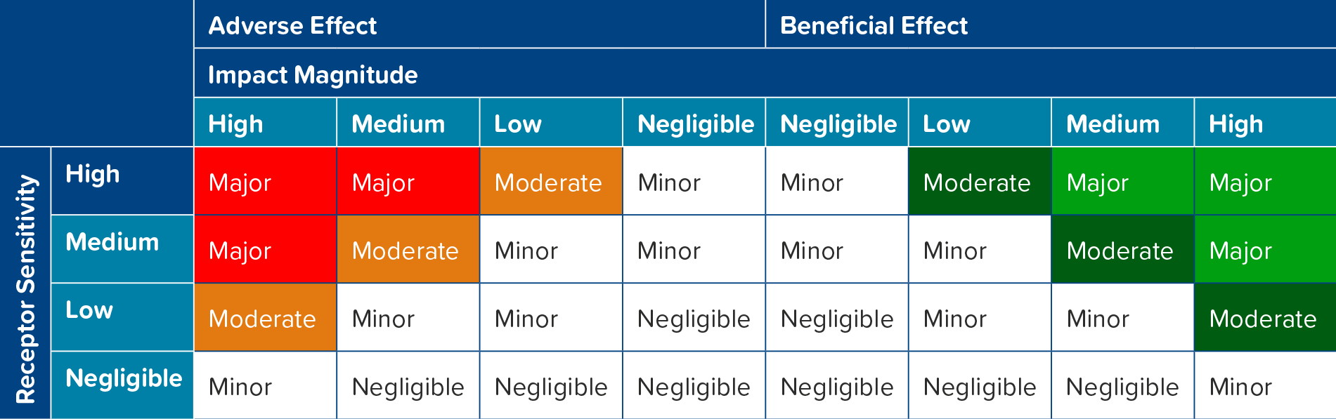
Assessment of Likely Significant Effects – The determination of the scale of an impact on a receptor when considered in the context of its sensitivity, value, and importance. A matrix approach (see Table 4.1) is used to ensure consistency and transparency in the assessment process.
Table 4.1 – EIA significance matrix
In EIA terms, an effect is generally considered ‘significant’ if it is defined as moderate or major (see Table 4.2). In some circumstances, a moderate effect may not be considered significant, in which case a justification is provided. This justification will be stated in the individual chapter referenced in the relevant section. If the effect is negligible, minor, or there is no change, it is not considered significant in EIA terms. Should the assessment find that the Project is likely to cause a significant environmental effect, additional measures are proposed to avoid or reduce these impacts to acceptable levels if possible. These mitigation measures are agreed upon through ongoing consultation with relevant statutory bodies and other key stakeholders. After applying the mitigation measures, the effects are reassessed to determine the final residual effect.
Significance
Definition
Major
Large changes to the receptor condition which may be adverse or beneficial. This is likely to be at a national or population level and consideration to national and statutory objectives should be noted.
Moderate
Intermediate changes to the receptor condition which may be regionally important.
Minor
Small changes to the receptor condition which may be locally important.
Negligible
No changes to the receptor condition.
Table 4.2 – EIA significance matrix
Mitigation measures are captured as Project commitments in a Commitments Register, where they are given a unique identification reference so they can be traced across PEIR documents and through subsequent stages in the EIA / DCO process.
The EIA will also assess:
Inter-relationships and interactions, where impacts to one receptor can have a knock-on impact on another (for example an impact on a fish population may lead to reduced prey for birds and marine mammals) or where multiple effects can act on a single receptor or receptor group;
Cumulative impacts, where the Project will be considered alongside the predicted impacts of other projects in the nearby area (for example another offshore wind farm or a road development); and
Transboundary impacts, where activities in other countries may be impacted (for example shipping routes and fishing activities). The relevant countries have been identified as Denmark, Belgium, Sweden, France, the Netherlands, Norway, Germany and Iceland.
4.3 Environmental Impact Tools
The Project has developed two EIA tools: the Impacts Register and the Commitments Register. These documents should be read with the PEIR.
The Impacts Register details ALL potential impacts that may arise during the construction, operation and maintenance, decommissioning of the Project associated with each EIA topic and identifies whether the impact has been scoped in or out of the assessments in the PEIR technical chapters.
The Commitments Register sets out ALL embedded and additional mitigation, enhancement and monitoring measures (collectively referred to as “commitments”) that have been identified through design evolution, stakeholder engagement and the EIA process. The Commitments Register will be maintained and updated through the pre-application stage and during the DCO application in response to ongoing stakeholder engagement and as more environmental and design information becomes available.
Alongside the Commitments Register, a number of Outline Management Plans have been prepared for consultation as part of the PEIR:
Outline Code of Construction Practice (Document Reference 8.9), including Appendix A: Outline Public Rights of Way Management Plan and Appendix B: Outline Site Waste Management Plan;
Outline Construction Traffic Management Plan (Document Reference 8.15);
Outline Marine Mammal Mitigation Plan (Document Reference 8.1); and
Outline Project Environmental Management Plan (Document Reference 8.6).
These plans outline how relevant commitments could be managed during the Project, allowing stakeholders to review and provide feedback on our proposals. They will be further developed following the PEIR and submitted with the DCO application.
Consultation with statutory and non-statutory consultees prior to the submission of a DCO application is an inherent part of the DCO process.
Engaging with a wide range of stakeholders and local communities, in addition to meeting statutory consultation requirements, is standard practice. This ensures that consultation extends beyond statutory consultees to include the general public.
Since July 2023, technical consultation has been ongoing with regulatory bodies and stakeholder groups. This includes discussions about the overall Project as well as specific topics through a process called the Evidence Plan Process.
This PEIR is presented and consulted on as part of the statutory consultation requirements under the Planning Act 2008. It helps those taking part in the consultation understand the Project’s nature, scale, location and likely significant environmental effects so far, so that they provide informed feedback, contributing to further development of the Project and the EIA process.
DBD will continue to engage with communities and stakeholders throughout the EIA process to ensure everyone stays informed, has the chance to participate in consultations and engagement activities and can provide feedback to help shape the Project’s design.
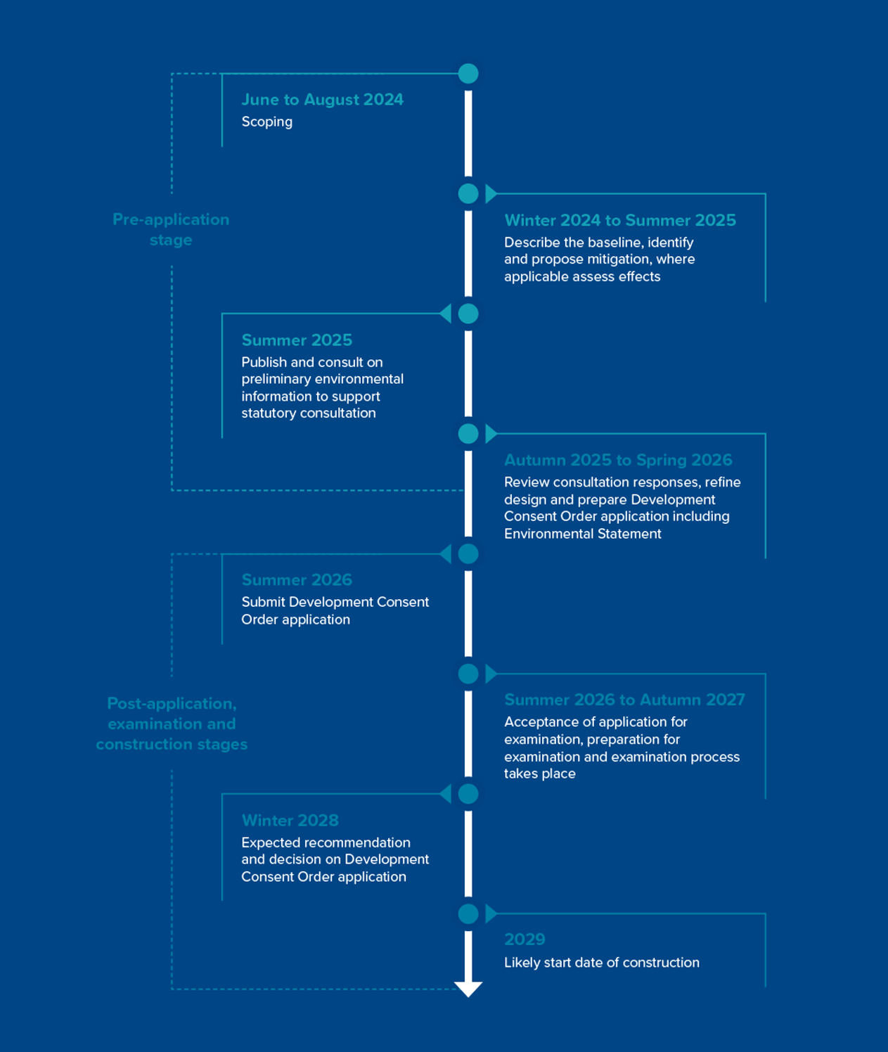
Figure 15 shows the consultation programme and a timeline of key milestones for the Project.
Figure 15 — Consultation programme and timeline of key milestones
The following sections set out a summary of the impact assessments presented in the PEIR chapters.
For each environmental topic the sections provide details of:
The baseline - what the environment is currently like for the specific topic;
The impacts considered in the assessment of effects;
Key proposed mitigation measures and commitments for reducing predicted effects; and
A summary of environmental effects.
At the end of the operational lifetime, the Project will be decommissioned. The details and scope of decommissioning works are not currently known and will be determined at the time of decommissioning and provided in an Onshore Decommissioning Plan and Offshore Decommissioning Programme. Therefore, in many of the technical assessments it is assumed that impacts during the decommissioning phase would be of a similar nature to, and no worse than, those identified during the construction phase.
6.1 Marine Physical Processes
6.1.1 Background
The Marine Physical Processes chapter considers the likely effects on waves, tides, water circulation, sediment transport and processes.
Information for this chapter was gathered by conducting site-specific surveys of the seabed, collecting sediment samples and undertaking modelling to predict how tides, waves, and sediment would be affected in the area.
Tidal currents flow to the northwest when the tide goes out (known as the ebb tide) and to the southeast when the tide comes in (known as the flood tide). As you get closer to the coast, tidal currents get stronger nearer to the shore. The seabed is mostly sandy, with small amounts of mud and movement of the sediment across the Array Area is driven predominantly by tidal currents. Waves in the Array Area mostly come from the north, while waves approaching the Holderness coast usually come from the northeast.
6.1.2 Assessment of Effects
Potential effects have been considered in the assessment. Table 6.1 presents a selection of key impacts assessed. A full list, including associated impact IDs, is available in the PEIR chapter and the Impacts Register.
Changes in suspended sediment concentration, sediment movement, and seabed level.
Foundation and cable installation and decommissioning.
Construction and decommissioning
MPP-C-06
Changes in seabed level.
Indentations created by installation vessels.
Construction
MPP-O-01 MPP-O-02 MPP-O-03 MPP-O-07
Changes in tidal currents, waves, movement of sediment and water circulation.
Presence of foundation structures on the seabed.
O&M
MPP-O-05
Interruption of sediment movement.
Presence of cable protection on the seabed.
O&M
MPP-O-06
Changes in sediment concentration, sediment movement and seabed level.
Cable repairs and reburial.
O&M
Table 6.1 - Selected Impacts Assessed on Marine Physical Processes
6.1.3 Mitigation and Enhancement Measures
Mitigation of potential effects is considered during the assessment and has been incorporated into the Project design through commitments. A full list is presented in the PEIR chapter and the Commitments Register. Some examples are shown in Table 6.2.
Commitment ID
Commitment
CO23
A trenchless technique will be used at landfall to install export cables to avoid impacts to Withow Gap SSSI.
CO26
Micro-siting of the offshore cables will be used to minimise the requirement for seabed preparation as far as practicable.
CO27
Cables will be buried where practicable to reduce the impact on the typical movement of sediment.
Following implementation of the embedded mitigation, the results of the assessment show no significant effects from the Project are anticipated in relation to marine physical processes.
For further information on this topic, please see:
The Marine Water and Sediment Quality chapter considers the likely effects on marine water and sediment quality.
Information for this chapter was gathered by conducting site-specific surveys, including collecting sediment samples and undertaking contaminant and sediment particle size analysis, which determines the variety of particle sizes present in the sediment sample.
The sediments were predominantly sandy with a high variation of gravel and cobbles with negligible contamination.
6.2.2 Assessment of Effects
Potential effects have been considered in the assessment. Table 6.3 presents a selection of key impacts assessed. A full list, including associated impact IDs, is available in the PEIR chapter and the Impacts Register.
Impact ID
Impact Activity
Activity
Project Phase
MWS-C-01
Increased suspended sediment concentrations affecting water quality.
Construction activities.
Construction
MWS-C-03 MWS-O-03 MWS-D-03
Remobilisation of existing contaminated sediments.
Construction, routine maintenance activities and decommissioning activities.
Construction, O&M and decommissioning
Table 6.3 - Selected Impacts Assessed on Marine Water and Sediment Quality
6.2.3 Mitigation and Enhancement Measures
Mitigation of potential effects is considered during the assessment and has been incorporated into the Project design through commitments. A full list is presented in the PEIR chapter and the Commitments Register. Some examples are shown in Table 6.4.
Commitment ID
Commitment
CO26
Micro-siting of the offshore cables will be used to minimise the requirement for seabed preparation as far as practicable.
CO27
Cables will be buried where practicable to reduce the impact on the typical movement of sediment.
CO28
An Offshore Operations and Maintenance Plan will be provided before operation commences to outline the reasonably foreseeable offshore operations and maintenance activities.
Table 6.4 - Selected Project Commitments relevant to Marine Water and Sediment Quality
6.2.4 Summary of Effects
The results of the assessments show that there would be no significant effects to marine water and sediment quality.
For further information on this topic, please see:
The Benthic and Intertidal Ecology chapter provides an overview of the existing seabed (i.e. benthic) and intertidal environment.
The assessment is based on both existing and site-specific survey data. Surveys of the seabed and intertidal zone were undertaken and data available from neighbouring offshore wind farms were used to provide a detailed understanding of the seabed ecology in the area. The data enables us to identify what the seabed is composed of (e.g. mud, sand, rock, etc.) and what seabed habitats are present.
The seabed across the Offshore Development Area is mainly sand with small amounts of mud (0-10%) and varying amounts of gravel / shell fragments. A total of 16 different types of seabed communities and habitats were identified, all of which are typical of those found in the southern North Sea. In addition, an intertidal survey at the landfall identified the habitat as a freely draining sandy beach, lacking any flora or fauna communities due to the constant movement of the sediment and sand.
6.3.2 Assessment of Effects
Potential effects have been considered in the assessment. Table 6.5 presents a selection of key impacts assessed. A full list, including associated impact IDs, is available in the PEIR chapter and the Impacts Register.
Impact ID
Impact
Activity
Project Phase
BEN-C-03
Increased suspended sediment re-deposition.
Installation of foundations, cables and any erosion protection.
Construction
BEN-C-05 BEN-O-05
Remobilisation of contaminated sediments.
Installation of foundations in the seabed and O&M activities.
Construction and O&M
BEN-C-07
Underwater noise and vibration.
Pile driving during construction activities and clearance of unexploded ordnance.
Construction
BEN-O-01
Temporary habitat loss and physical disturbance.
Maintenance activities, cable repairs and reburials
O&M
BEN-O-02
Habitat loss and alteration.
Presence of foundations, cables and scour protection on the seabed.
O&M
BEN-O-11
Colonisation of new underwater substrates and materials with benthic invertebrate species.
Presence of sub-sea structures including foundations.
O&M
Table 6.5 - Selected Impacts Assessed on Benthic and Intertidal Ecology
6.3.3 Mitigation and Enhancement Measures
Mitigation of potential effects is considered during the assessment and has been incorporated into the Project design through commitments. A full list is presented in the PEIR chapter and the Commitments Register. Some examples are shown in Table 6.6.
Commitment ID
Commitment
CO24
Where possible, cable burial is the preferred method of cable protection. Where cable protection is required, it will be minimised where feasible. This will be set out in a Cable Specification and Installation Plan.
CO26
Micro-siting of the offshore cables will be used to minimise the requirement for seabed preparation as far as practicable.
CO28
An Offshore Operations and Maintenance Plan will be provided before operation commences to outline the reasonably foreseeable offshore operations and maintenance activities.
CO29
An In-Principle Monitoring Plan will be produced to set out relevant monitoring requirements during construction and operation and maintenance phases in the marine environment.
Table 6.6 - Selected Project Commitments relevant to Benthic and Intertidal Ecology
6.3.4 Summary of Effects
Effects are generally temporary and localised in nature, being restricted to the Project’s boundaries and immediate surrounding area. Overall, considering the mitigation proposed as part of the assessment, no significant effects are identified upon seabed and intertidal habitats and species.
For further information on this topic, please see:
The Fish and Shellfish Ecology Chapter provides an overview of the existing fish and shellfish ecology environment.
Desk based data including scientific survey data, landings data and peer-reviewed literature has been used alongside information gathered during sitespecific environmental and seabed surveys to inform the characterisation of the baseline and the assessments.
6.4.2 Assessment of Effects
Potential effects have been considered in the assessment. Table 6.7 presents a selection of key impacts assessed. A full list, including associated impact IDs, is available in the PEIR chapter and the Impacts Register.
Impact ID
Impact
Activity
Project Phase
FSE-C-02 FSE-O-02
Temporary habitat loss and physical disturbance.
Construction and O&M activities.
Construction and O&M
FSE-C-04
Increased suspended sediment and sediment re-deposition.
Construction activities.
Construction
FSE-C-06 FSE-O-06
Remobilsation of contaminated sediments if present.
Construction activities including installation of cables and routine O&M.
Construction and O&M
FSE-C-07
Underwater noise and vibration leading to displacement of fish species and effects on spawning behaviour.
Construction activities including pile driving.
Construction
FSE-O-03
Habitat loss and alteration.
Presence of foundations and scour protection leading to lost habitat.
O&M
FSE-O-10
Sediment heating.
Export cables heating during transmission of electricity.
O&M
Table 6.7 - Selected Impacts Assessed on Fish and Shellfish Ecology
6.4.3 Mitigation and Enhancement Measures
Mitigation of potential effects is considered during the assessment and has been incorporated into the Project design through commitments. A full list is presented in the PEIR chapter and the Commitments Register. Some examples are shown in Table 6.8.
Commitment ID
Commitment
CO22
A piling Marine Mammal Mitigation Protocol will be implemented during construction and will set out measures used to minimise potential physical injury to marine mammals and sensitive fish species. This includes measures such as soft-start and ramp-up to encourage sensitive species to move away from the construction area.
CO24
Where possible, cable burial is the preferred method of cable protection. Where cable protection is required, it will be minimised where feasible. This will be set out in the Cable Specification and Installation Plan.
CO26
Micro-siting of the offshore cables will be used to minimise the requirement for seabedpreparation as far as practicable.
CO28
An Offshore Operations and Maintenance Plan will be provided before operation commences to outline the reasonably foreseeable offshore operations and maintenance activities.
Table 6.8 - Selected Project Commitments Relevant to Fish and Shellfish Ecology
6.4.4 Summary of Effects
Following implementation of the embedded mitigation no significant effects from the Project are anticipated in relation to fish and shellfish ecology.
For further information on this topic, please see:
The Marine Mammals chapter assesses the potential impact of the Project on marine mammals, including seals, porpoise, whales and dolphins.
Site-specific surveys, existing data from other offshore wind farms and other available information for the region identified the presence of the following key marine mammal species:
Harbour porpoise;
Bottlenose dolphin;
Minke whale;
Grey seal; and
Common dolphin;
White-beaked dolphin;
Harbour seal.
6.5.2 Assessment of Effects
Potential effects have been considered in the assessment. Table 6.9 presents a selection of key impacts assessed. A full list, including associated impact IDs, is available in the PEIR chapter and the Impacts Register.
Impact ID
Impact
Activity
Project Phase
MM-C-01 MM-C-02 MM-C-05 MM-C-06
Physical and auditory injury and behavioural impacts caused by underwater noise. This can affect hearing and can lead to displacement.
Pile driving and other construction activities including dredging and rock placement.
Construction
MM-C-08 MM-O-08
Disturbance at seal haul-out sites due to vessel noise.
Vessel movements to and from site during construction and O&M.
Construction and O&M
MM-C-09 MM-O-09
Vessel interaction and associated collision risk.
Vessels used during construction and O&M.
Construction and O&M
MM-C-10 MM-O-10
Indirect impact from changes to food sources that marine mammals feed on, including fish.
Construction and O&M activities leading to changes in habitats, fishing pressures, water quality and a reduction in fish species.
Construction and O&M
MM-O-05
Underwater noise causing physical and auditory injury and displacement.
Maintenance activities including dredging and rock placement and operational noise from wind turbines.
O&M
MM-O-13
Physical barrier effect from O&M activities.
The presence of wind farm infrastructure may create a barrier to movement.
O&M
Table 6.9 - Selected Impacts Assessed on Marine Mammals
6.5.3 Mitigation and Enhancement Measures
Mitigation of potential effects is considered during the assessment and has been incorporated into the Project design through commitments. A full list is presented in the PEIR chapter and the Commitments Register. Some examples are shown in Table 6.10.
Additional mitigation measures to reduce underwater noise effects of piling activities and other measures to reduce disturbance are also proposed.
Commitment ID
Commitment
CO18
A Vessel Traffic Management Plan will be produced as part of the Project Environmental Management Plan (PEMP) which will aim to minimise encounters with marine mammals and common scoter and red-throated diver.
CO19
Should the Ecological Clerk of Works observe high densities of Red Throated Diver and Common Scoter species during construction, mitigation measures will be adopted to reduce disturbance as needed, such as temporary stoppage of those construction activities causing disturbance, in turn having indirect benefits for marine mammals.
CO22
A piling Marine Mammal Mitigation Protocol will be implemented during construction and will set out measures used to minimise potential physical injury to marine mammals and sensitive fish species. This includes measures such as soft-start and ramp-up to encourage sensitive species to move away from the construction area.
CO28
An Offshore Operations and Maintenance Plan will be provided before operation commences to outline the reasonably foreseeable offshore operations and maintenance activities.
Table 6.10 - Selected Project Commitments Relevant to Marine Mammals
6.5.4 Summary of Effects
Underwater noise from piling will only occur during the offshore construction phase and is expected to be shortterm. While some marine mammals may temporarily leave the area, they are expected to return once piling is complete. Noise from operational turbines or other construction or maintenance work is minimal and unlikely to cause any long-term effect on marine mammal populations. Any changes to their food sources are closely linked with impacts to water quality but both will be very low, and alternative feeding areas are available within the animals’ natural ranges.
There is the potential for significant impacts to some marine mammal species if multiple noisy activities are carried out at the same time, e.g. if all planned offshore wind farms were to pile within the same period. However, further planning for noise mitigation and management measures will be explored as part of the DCO application to minimise these risks and ensure that marine mammal populations are not significantly affected by the Project.
Following implementation of the embedded mitigation, no significant impacts from the Project are anticipated in relation to marine mammals.
The Offshore and Intertidal Ornithology chapter assesses the potential impacts of the Project on offshore and intertidal ornithological receptors. Site-specific Digital Aerial Surveys were conducted alongside a desk-based review which identified the following key species using these areas:
Kittiwake;
Great black-backed gull;
Herring gull;
Lesser black-backed gull;
Little auk;
Guillemot;
Razorbill;
Puffin;
Common scoter;
Red-throated diver;
Great northern diver;
White-billed diver; and
Gannet.
6.6.2 Assessment of Effects
Potential effects have been considered in the assessment. Table 6.11 presents a selection of key impacts assessed. A full list, including associated impact IDs, is available in the PEIR chapter and the Impacts Register.
Cumulative impacts with other relevant projects for operational disturbance and displacement and for collision risk during construction were also assessed.
The potential for a significant effect due to cumulative disturbance and displacement could not be ruled out at this stage for guillemot, razorbill, puffin and gannet. Similarly, the potential for significant effects due to cumulative collision risk could not be ruled out for gannet or kittiwake at this stage.
Impact ID
Impact
Activity
Project Phase
ORN-C-01 ORN-O-01 ORN-D-01
Direct disturbance and displacement in the Array Area, Offshore ECC or landfall.
Installation, maintenance and removal of offshore and landfall infrastructure.
Construction, O&M and decommissioning
ORN-C-02 ORN-O-02 ORN-D-02
Direct disturbance and displacement due to presence of wind turbines and other offshore infrastructure.
Installation, presence and removal of wind turbines and other offshore infrastructure.
Construction, O&M and decommissioning
ORN-C-03
Wind turbines creating obstacles to commuting and migration in birds, creating a barrier effect that can increase energy expenditure.
Presence of wind turbines in the array area.
O&M
ORN-C-06
Risk of flying birds colliding with offshore wind turbines.
Presence of wind turbines in the array area.
O&M
Table 6.11 - Selected Impacts Assessed on Offshore and Intertidal Ornithology
6.6.3 Mitigation and Enhancement Measures
Mitigation of potential effects is considered during the assessment and has been incorporated into the Project design through commitments. A full list is presented in the PEIR chapter and the Commitments Register. Some examples are shown in Table 6.12.
Commitment ID
Commitment
CO13
There will be a minimum blade tip clearance of at least 26m above the Highest Astronomical Tide, and 28m above the Lowest Astronomical Tide, reducing the overlap between the height of the blades and the core flying ranges of seabirds.
CO18
A Vessel Traffic Management Plan will be produced as part of the Project Environmental Management Plan (PEMP) which will aim to minimise encounters with marine mammals and common scoter and red-throated diver.
CO19
Should the Ecological Clerk of Works observe high densities of Red Throated Diver and Common Scoter species during construction, mitigation measures will be adopted to reduce disturbance as needed, such as temporary stoppage of those construction activities causing disturbance.
CO30
An Ornithological Monitoring Plan will set out proposals for ornithological monitoring.
Table 6.12 - Selected Project Commitments Relevant to Offshore and Intertidal Ornithology
6.6.4 Summary of Effects
Project alone assessments conclude no significant effects to species named in section 6.6.1. However, there is potential for significant effects due to cumulative disturbance and displacement and cumulative collision risk for gannet or kittiwake, which could not be ruled out at this stage.
With the committed mitigation measures, the Project does not result in significant effects on offshore ornithology receptors alone.
Next steps include:
Ongoing data updates – the Project will continue to monitor the publication of relevant scientific studies to the species assessed in this chapter including updated colony counts– these will be incorporated into the ES where appropriate;
Further detailed modelling will be carried out prior to ES stage to inform assessment of effects on a population level;
The Project will further investigate the impact of cumulative effects at ES stage alongside refinement to assessment approaches;
Ongoing consultation will be carried out with stakeholders throughout 2025 to explore options to refine the approach to assessment; and
The Project will continue to look into potential further effective mitigation options.
The Commercial Fisheries chapter assesses the potential impacts of the Project on commercial fisheries. The term ‘commercial fisheries’ refers to legally permitted fishing activity where the catch is sold for profit which is then taxed.
Key species landed in the Study Area include lobsters, brown crabs, king scallops, herring and plaice, caught using a variety of fishing methods such as pots, dredges and trawls.
Impact ID
Impact
Activity
Project Phase
CF-C-02 CF-O-02
Exclusion from, or reduction in access to, established fishing grounds.
Installation activities and physical presence of constructed infrastructure.
Construction and O&M
CF-C-03 CF-O-03
Displacement of fishing activity from the Project footprint leading to gear conflict and increased fishing pressure on adjacent / alternative grounds.
Construction activities, including the presence of installation vessels, operational activities and the physical presence of constructed infrastructure.
Construction and O&M
CF-C-04 CF-O-04
Displacement of commercially important fish and shellfish resources.
Construction activity, including the presence of installation vessels.
Construction and O&M
CF-C-07 CF-O-07
Direct interference with fishing activities.
Increased vessel traffic associated with project construction and O&M phases as well as physical presence of project infrastructure.
Construction and O&M
CF-O-09
Damage to fishing gear through gear snagging.
Physical presence of infrastructure leading to potential snagging points for fishing gear.
O&M
Table 6.13 - Selected Impacts Assessed on Commercial Fisheries
6.7.3 Mitigation and Enhancement Measures
Mitigation of potential effects is considered during the assessment and has been incorporated into the Project design through commitments. A full list is presented in the PEIR chapter and the Commitments Register. Some examples are shown in Table 6.14.
Commitment ID
Commitment
CO9
Aids to navigation (marking and lighting) will be used to ensure that infrastructure is clearly visible at sea, in line with latest standard industry guidance.
CO11
Advanced warning and accurate location details of construction, maintenance, and decommissioning work, safety zones and safe passing distances will be given via Notifications to Mariners and Kingfisher Bulletins at least 14 days in advance of works where possible.
CO15
Liaison with fisheries will be undertaken with a company Fisheries Liaison Officer being appointed to maintain effective communication between the Project and fishermen and ensure they are being fully informed of development planning and offshore activities. This also commits the Applicant to exploring options to encourage co-existence and further mitigate any effect of the Project, including via cooperation agreements and associated payments.
CO17
Safety zones of up to 500m will be applied during construction, major maintenance and decommissioning phases and up to 50m for installed structures. Guard vessels will be used where appropriate to ensure safety zones are adhered to.
CO24
Where possible, cable burial will be the preferred method of cable protection to minimise the risk to fishing techniques on the seabed.
Table 6.14 - Selected Project Commitments Relevant to Commercial Fisheries
6.7.4 Summary of Effects
Following implementation of the mitigation measures no significant impacts from the Project are anticipated in relation to commercial fisheries.
The Shipping and Navigation chapter considers the likely effects on shipping and navigation users.
Information for this chapter was gathered using deskbased sources, as well as conducting a summer vessel traffic survey to understand vessel movements.
The Array Area and Offshore ECC are used by cargo vessels, tankers and fishing vessels in transit. A total of seven Main Commercial Routes were identified within the shipping and navigation Study Area from the vessel traffic data.
6.8.2 Assessment of Effects
Potential effects have been considered in the assessment. Table 6.15 presents a selection of key impacts assessed. A full list, including associated impact IDs, is available in the PEIR chapter and the Impacts Register.
Impact ID
Impact
Activity
Project Phase
SN-C-01 SN-O-01 SN-D-01
Vessel displacement.
Construction and decommissioning of the Project as well as its physical presence.
Construction, O&M and decommissioning
SN-C-02 SN-O-02 SN-D-02 SN-C-03 SN-O-03 SN-D-03
Increased vessel to vessel collision risk between third-party vessels and between third-party and project vessels due to vessel displacement.
Construction, operation and decommissioning of the structures and sub-sea cables displacing third-party vessels from their existing routes which may increase collision risk.
Construction, O&M and decommissioning
SN-O-04
Increased risk of third-party vessels colliding with the project structures.
Presence of the project structures within the Array Area.
O&M
SN-O-08
Reduction in emergency response capability due to increased incident rates or reduced access for search and rescue responders.
Presence of the project structures within the Array Area.
O&M
Table 6.15 - Selected Impacts Assessed on Shipping and Navigation
6.8.3 Mitigation and Enhancement Measures
Mitigation of potential effects is considered during the assessment and has been incorporated into the Project design through commitments. A full list is presented in the PEIR chapter and the Commitments Register. Some examples are shown in Table 6.16.
Commitment ID
Commitment
CO9
Aids to navigation (marking and lighting) will be used to ensure that infrastructure is clearly visible at sea, in line with latest standard industry guidance.
CO11
Advanced warning and accurate location details of construction, maintenance, and decommissioning work, safety zones and safe passing distances will be given via Notifications to Mariners and Kingfisher Bulletins at least 14 days in advance of works where possible.
CO15
Liasion with fisheries will be undertaken with a company Fisheries Liaison Officer being appointed to maintain effective communication between the Project and fishermen and ensure they are being fully informed of development planning and offshore activities. This also commits the Applicant to exploring options to encourage co-existence and further mitigate any effect of the Project, including via cooperation agreements and associated payments.
CO17
Safety zones of up to 500m will be applied during construction, major maintenance and decommissioning phases and up to 50m for installed structures. Guard vessels will be used where appropriate to ensure safety zones are adhered to.
CO24
Where possible, cable burial will be the preferred method of cable protection to minimise the risk to fishing techniques on the seabed.
CO28
An Offshore Operations and Maintenance Plan will be provided before operation commences to outline the reasonably foreseeable offshore operations and maintenance activities.
Table 6.16 - Selected Project Commitments Relevant to Commercial Fisheries
6.8.4 Summary of Effects
Following implementation of the mitigation measures no significant effects from the Project alone are anticipated in relation to shipping and navigation.
There is a potential for significant effects on shipping and navigation when assessed cumulatively with the Dogger Bank South Offshore Wind Farm. Further consideration of cumulative effects and potential further mitigation will be considered for the ES.
Next steps include:
Holding a Hazard Workshop with relevant stakeholders;
Carrying out summer and winter vessel traffic surveys; and
Updating assessments prior to ES with the results of the survey and a review of the Royal Yachting Association Coastal Atlas of Recreational Boating.
For further information on this topic, please see:
The Aviation, Radar and Military chapter assesses the potential impact of the Project on aviation, radar and military receptors. For example, offshore wind farm infrastructure can present a physical obstruction for low flying aircraft such as offshore helicopters and rotating wind turbine blades can have a detrimental effect on how aviation radars work.
There are no licensed airfields or radars nearby, but Beverley Airfield is close to the proposed onshore ECC. Civil and military aircraft use the airspace above, and part of the offshore cable corridor overlaps with military danger zones. The closest helideck is the Tolmount helideck, located 9 nautical miles from the offshore ECC.
6.9.2 Assessment of Effects
Potential effects have been considered in the assessment. Table 6.17 presents a selection of key impacts assessed. A full list, including associated impact IDs, is available in the PEIR chapter and the Impacts Register.
Impact ID
Impact
Activity
Project Phase
ARM-C-03 ARM-O-03 ARM-D-03
Creating an aviation obstacle environment for low-level military aircraft, helicopters flying to offshore oil and gas platforms and Search and Rescue helicopters.
The presence of completed wind turbines, offshore substation platforms during operation and high crane vessels used during construction and decommissioning.
Construction, O&M and decommissioning
ARM-C-04 ARM-O-04 ARM-D-04
Increased air traffic in the area related to wind farm activity.
Air traffic such as helicopters used for Project construction, O&M and decommissioning activities.
Construction, O&M and decommissioning
ARM-C-05 ARM-O-05 ARM-D-05
Interference with military exercises on Staxton Danger Area.
Vessels engaged in cable-laying, cable maintenance or cable decommissioning.
Construction, O&M and decommissioning
ARM-C-06 ARM-O-06 ARM-D-06
Impact of onshore infrastructure on airfield operations at Beverley Airfield.
Presence of onshore infrastructure including tall buildings and / or stacks.
Construction, O&M and decommissioning
Table 6.17 - Selected Impacts Assessed on Aviation, Radar and Military
6.9.3 Mitigation and Enhancement Measures
Mitigation of potential effects is considered during the assessment and has been incorporated into the Project design through commitments. A full list is presented in the PEIR chapter and the Commitments Register. Some examples are shown in Table 6.18.
Commitment ID
Commitment
CO8
The Defence Infrastructure Organisation and the Civil Aviation Authority (CAA) will be informed of the locations, heights and lighting status of the wind turbines, including estimated and actual dates of construction and the maximum height of any construction equipment to be used, prior to the start of construction, to allow inclusion on Aviation Charts in line with Article 225a of the Air Navigation Order.
CO9
Aids to navigation (marking and lighting) will be used to ensure that infrastructure is clearly visible at sea, in line with latest standard industry guidance and as advised by the Ministry of Defence where appropriate.
CO24
Where possible, cable burial will be the preferred method of cable protection to minimise the risk to fishing techniques on the seabed.
CO28
An Offshore Operations and Maintenance Plan will be provided before operation commences to outline the reasonably foreseeable offshore operations and maintenance activities. This will inform search and rescue resources of helicopter traffic engaged in works on the Project.
Table 6.18 - Selected Project Commitments Relevant to Aviation, Radar and Military
6.9.4 Summary of Effects
Following implementation of the mitigation no significant effects from the Project alone are anticipated in relation to aviation, radar and military receptors.
The proximity of the Project to the Dogger Bank C and Sofia offshore wind farms, currently under construction, may generate cumulative effects in terms of physical obstructions and increased air traffic.
However, with embedded mitigation and compliance with aviation regulatory requirements and national procedures, no significant effects are anticipated.
The Offshore Archaeology chapter considers the effects of the Project on offshore archaeology. The assessment is based on existing data and site-specific surveys.
There are no known prehistoric sites in the Offshore Development Area, but there is potential for submerged prehistoric archaeology (including geoarchaeological/ palaeoenvironmental deposits), that have not previously been discovered. This potential will be studied further with the results included in the ES.
Surveys, mainly covering the Array Area, have shown the presence of 259 seabed features with archaeological potential, including two wrecks. Further wrecks have previously been recorded in the offshore ECC, which has not yet been investigated with site specific surveys.
However, surveys are ongoing, and these results will be included in the ES. This could include maritime or aviation sites in the footprint of the Array Area or ECC which have not yet been discovered.
In the intertidal zone, there is high potential for archaeological remains from prehistoric, medieval, postmedieval, and 20th-century periods.
6.10.2 Assessment of Effects
Potential effects have been considered in the assessment. Table 6.19 presents a selection of key impacts assessed. A full list, including associated impact IDs, is available in the PEIR chapter and the Impacts Register.
Direct physical impacts, or damage, to known and potential heritage assets.
Construction activities such as cabling, foundations or use of jackup vessels.
Routine and non-routine O&M activities which may disturb the seabed such as contact with the seabed by jack-up vessels or the use of anchors.
Decommissioning activities.
Construction, O&M and decommissioning
OFA-C-03 OFA-O-03 OFA-D-03
Indirect impacts to heritage assets caused by sediment disturbance and movement and changes to hydrodynamics.
Physical presence of construction vessels and offshore infrastructure leading to changes in sediment transport and hydrodynamics. Also, the presence of the offshore infrastructure itself and any O&M activities as well as decommissioning activities.
Construction, O&M and decommissioning
Table 6.19 - Selected Impacts Assessed on Offshore Archaeology and Cultural Heritage
6.10.3 Mitigation and Enhancement Measures
Mitigation of potential effects is considered during the assessment and has been incorporated into the Project design through commitments. A full list is presented in the PEIR chapter and the Commitments Register. Some examples are shown in Table 6.20.
Commitment ID
Commitment
CO1
Mitigation measures to offset the effects on offshore archaeology will be discussed with Historic England and set out in an Offshore Written Scheme of Investigation (WSI).
CO2 CO6
Archaeological Exclusion Zones (AEZs) will be determined and set out in a Layout Plan. These will aim to avoid areas of the seabed where archaeological features may be present and where they are known to be present.
CO3 CO5
Archaeologists will input into the design of any future pre-construction surveys of the seabed, including setting out what analysis should take place from an archaeological perspective. They may also determine whether any sampling is required. This includes geophysical surveys and diver surveys.
CO28
An Offshore Operations and Maintenance Plan will be provided before operation commences to outline the reasonably foreseeable offshore operations and maintenance activities. This will inform search and rescue resources of helicopter traffic engaged in works on the Project.
Table 6.20 - Selected Project Commitments Relevant to Offshore Archaeology and Cultural Heritage
6.10.4 Summary of Effects
Following implementation of the mitigation no significant effects from the Project are anticipated in relation to offshore archaeology and cultural heritage.
A potential beneficial effect may be the contribution of data to academic and scientific research. The approach will be developed post-consent, in consultation with key stakeholders, including Historic England. This would also be set out in an Offshore Written Scheme of Investigation.
Next steps include:
Ongoing work to obtain marine geophysical data, using techniques such as sonar or radar to look at the physical properties of the sea floor and the layers underneath it, particularly from the offshore ECC.
Once this data has been received and assessed, the results will be discussed with Historic England to determine where Archaeological Exclusion Zones should be located.
The Other Marine Users chapter provides an assessment of potential impacts on other marine users and residual effects following the implementation of mitigation measures.
The potential for interactions between the Project and the following other marine users has been identified:
Other nearby offshore wind farms;
Oil and gas infrastructure;
Electrical infrastructure;
Carbon capture and storage;
Aggregate extraction sites;
Dumping and disposal sites; and
Ministry of Defence activities.
Commercial fisheries and shipping and navigation are considered separately (see Sections 6.7 and 6.8).
6.11.2 Assessment of Effects
Potential effects have been considered in the assessment. Table 6.21 presents a selection of key impacts assessed. A full list, including associated impact IDs, is available in the PEIR chapter and the Impacts Register.
Impact ID
Impact
Activity
Project Phase
OMU-C-01 OMU-O-01 OMU-D-01
Potential interference with other wind farms.
Development of the project and associated construction, O&M and decommissioning activities.
Construction, O&M and decommissioning
OMU-C-02 OMU-O-02 OMU-D-02
Potential interference with oil and gas activities.
Development of the project and associated construction, O&M and decommissioning activities.
Construction, O&M and decommissioning
OMU-C-03 OMU-O-03 OMU-D-03
Physical impacts on subsea cables and pipelines.
Development of the project and associated construction, O&M and decommissioning activities.
Construction, O&M and decommissioning
OMU-C-04 OMU-O-04 OMU-D-04
Potential impacts on Carbon Capture and Storage sites.
Development of the project and associated construction, O&M and decommissioning activities.
Construction, O&M and decommissioning
Table 6.21 - Selected Impacts Assessed on Other Marine Users
6.11.3 Mitigation and Enhancement Measures
Mitigation of potential effects is considered during the assessment and has been incorporated into the Project design through commitments. A full list is presented in the PEIR chapter and the Commitments Register. Some examples are shown in Table 6.22.
Commitment ID
Commitment
CO9
Aids to navigation (marking and lighting) will be used to ensure that infrastructure is clearly visible at sea, in line with latest standard industry guidance and as advised by the Ministry of Defence where appropriate.
CO11
Advanced warning and accurate location details of construction, maintenance, and decommissioning work, safety zones and safe passing distances will be given via Notifications to Mariners and Kingfisher Bulletins at least 14 days in advance of works where possible.
CO14
Implementation of marine coordination for vessels involved in construction and maintenance to limit the effects on other marine users.
CO16
There will be appropriate marking of all offshore infrastructure on UK Hydrographic Office Admiralty Charts to aid navigation and maximise awareness of the infrastructure.
CO28
An Offshore Operations and Maintenance Plan will be provided before operation commences to outline the reasonably foreseeable offshore operations and maintenance activities. This will inform search and rescue resources of helicopter traffic engaged in works on the Project.
Table 6.22 - Selected Project Commitments Relevant to Other Marine Users
6.11.4 Summary of Effects
Following implementation of the mitigation no significant effects from the Project are anticipated in relation to other marine users.
The Geology and Ground Conditions chapter provides an assessment of the potential impacts to onshore geology and ground conditions.
The Onshore Development Area has different types of soil and rock, including glacial deposits, sand, gravel, and chalk. Chalk is important for local water supplies because it holds a lot of water. There are also other water sources in the Onshore Development Area.
There are places nearby where groundwater is abstracted, and some parts of the Onshore Development Area are protected to prevent contamination.
There are many streams and ditches, and the area overlaps with the River Hull. The Withow Gap is a geological Site of Special Scientific Interest (SSSI), and Skipsea Drain is a local geological site. There are also areas known as Mineral Safeguarding Areas where sand, gravel, and chalk are protected for future use.
Potential contamination sources include chemicals from farming, filled-in pits, railway land, an old pumping station, and old landfill sites.
6.12.2 Assessment of Effects
Potential effects have been considered in the assessment. Table 6.23 presents a selection of key impacts assessed. A full list, including associated impact IDs, is available in the PEIR chapter and the Impacts Register.
Impact ID
Impact
Activity
Project Phase
GGC-C-01
Contamination from on-site and offsite sources may cause impacts to human health.
Construction works either causing or disturbing contamination in soils and groundwater.
Construction
GGC-C-02 GGC-O-02 GGC-D-02
Impacts to the quality of groundwater from contamination.
Where there is already contamination in the ground, construction, operation and decommissioning activities may disturb this and cause it to affect groundwater. Accidental spillages and leakages during construction could more easily spread and infiltrate into groundwater.
Construction, O&M and decommissioning
GGC-C-03 GGC-O-03 GGC-D-03
Impacts on surface water quality and the ecology that interacts with it due to contamination.
Where there is already contamination in the ground, construction, operation and decommissioning activities may disturb this and cause it to affect groundwater. Accidental spillages and leakages during construction could more easily spread and infiltrate into groundwater.
Construction, O&M and decommissioning
GGC-C-04 GGC-O-04 GGC-D-04
Direct impacts to protect geological sites.
Ground breaking activities that directly overlap with the protected sites including trenching, excavation and piling. Also the presence of permanent infrastructure and decommissioning activities.
Construction, O&M and decommissioning
GGC-C-07 GGC-O-07 GGC-D-07
Lessening the quality of agricultural land by disturbing existing contamination.
Construction, O&M and decommissioning activities such as trenching, excavation, piling, movement and stockpiling of soil.
Construction, O&M and decommissioning
Table 6.23 - Selected Impacts Assessed on Geology and Ground Conditions
6.12.3 Mitigation and Enhancement Measures
Mitigation of potential effects is considered during the assessment and has been incorporated into the Project design through commitments. A full list is presented in the PEIR chapter and the Commitments Register. Some examples are shown in Table 6.24.
Commitment ID
Commitment
CO23
A trenchless technique will be used at landfall to install export cables to avoid impacts to Withow Gap SSSI.
CO33
Major watercourses, defined by the Environment Agency as Main Rivers, and those maintained by the Internal Drainage Board (IDB) will be crossed using trenchless techniques meaning that the watercourse will not be disturbed. Entry and exit points will be located 20m away from the bank for Main Rivers and 9m away for IDB drains. This limits the potential impacts to surface water quality resulting from construction activities.
CO35 CO36
Suitable methods for crossing watercourses will be agreed with relevant authorities before construction works start.
CO39
A Code of Construction Practice will be developed to help prevent pollution and ensure soil is managed properly during construction. It will also outline the steps to take if unexpected contaminated material is found. A draft Outline Code of Construction Practice (document reference 8.9) is provided with the PEIR.
CO42
Where potential sources of contamination have been identified, appropriate ground investigation and assessment will be completed to accurately characterise the risk if necessary. If required, suitable remediation measures will be implemented to reduce the potential impact to acceptable levels.
CO38, CO40 CO46, CO47 CO49, CO51 CO53, CO54, CO94
Appropriate soils, materials and waste management processes will be in place and will be agreed with the relevant authorities including the Environment Agency. Pollution prevention measures and emergency responses will be set out in appropriate documentation including the Onshore O&M Plan.
Table 6.24 - Selected Project Commitments Relevant to Geology and Ground Conditions
6.12.4 Summary of Effects
Following implementation of the mitigation no significant effects from the Project are anticipated in relation to geology and ground conditions.
The Air Quality and Dust chapter provides an assessment of the potential impacts relevant to air quality and dust.
Some activities related to the Project – such as construction work, vehicle movements, and transporting equipment - could release pollutants into the air, including nitrogen dioxide, ammonia and fine particles. These pollutants can affect both human health and the environment. Studies have been carried out to understand the possible effects of these emissions on people living nearby and on sensitive natural areas.
Studies have shown that the air quality in the area is generally good and within legal limits for people. However, some sensitive ecological features are exposed to pollution levels that could harm them.
6.13.2 Assessment of Effects
Potential effects have been considered in the assessment. Table 6.25 presents a selection of key impacts assessed. A full list, including associated impact IDs, is available in the PEIR chapter and the Impacts Register.
Impacts to local people and ecology resulting from emissions of dust and fine particles.
Earthworks, stockpiling of soil and the use of construction compounds can create dust. Also, pollutants from the exhaust fumes of the vehicles used in construction, O&M and decommissioning.
Construction, O&M and decommissioning
AQ-O-02
Pollution due to exhaust emissions from the backup generators and vehicles used during the O&M phase.
Operational use of backup generators at the OCS and road vehicles.
O&M
Table 6.25 - Selected Impacts Assessed on Air Quality and Dust
6.13.3 Mitigation and Enhancement Measures
Mitigation of potential effects is considered during the assessment and has been incorporated into the Project design through commitments. A full list is presented in the PEIR chapter and the Commitments Register. Some examples are shown in Table 6.26.
Commitment ID
Commitment
CO39
A Code of Construction Practice will be developed including measures to reduce impacts of the Project on air quality such as dust suppression techniques, wheel washing systems and appropriate storage of sand and other construction materials.
CO33
An Air Quality Management Plan will be included as part of the Code of Construction Practice in line with latest regulatory guidance. This will include site-specific measures to reduce impacts on air quality.
CO73 CO75
A Construction Traffic Management Plan will detail how peak construction traffic flows will be managed. Heavy goods vehicles will be routed to reduce vehicle movements on public highways as much as possible.
Table 6.26 - Selected Project Commitments Relevant to Air Quality and Dust
6.13.4 Summary of Effects
Following implementation of the mitigation measures no significant effects in relation to air quality from the Project are anticipated in relation to human receptors.
The effects of construction vehicle exhaust emissions on sensitive ecological habitats are addressed in:
The Water Resources and Flood Risk chapter assesses the potential impacts of the Project on water resources and flood risk receptors.
There are several watercourses which provide drainage of surface water in the area, with the primary drainage feature being the River Hull. Water quality is moderate and is affected by sewage and land management. The area has chalk bedrock, which holds a lot of water for local supplies. Some parts are protected to prevent contamination.
The area is low-lying, so some parts are at risk of flooding. Two nationally protected sites (Withow Gap and Leven Canal SSSIs) are in the area, with several others nearby, featuring wetland habitats.
6.14.2 Assessment of Effects
Potential effects have been considered in the assessment. Table 6.27 presents a selection of key impacts assessed. A full list, including associated impact IDs, is available in the PEIR chapter and the Impacts Register.
Impact ID
Impact
Activity
Project Phase
WRF-C-01 WRF-D-01
Direct disturbance to surface water bodies.
Crossing of water bodies by both the onshore ECC and haul road requiring use of crossing techniques. Also construction of the OCS and the ESBI and decommissioning activities.
Construction and decommissioning
WRF-C-02 WRF-D-02
Increased supply of sediment.
Disturbance of sediment by construction and decommissioning activity.
Construction and decommissioning
WRF-C-03 WRF-O-03 WRF-D-03
Supply of contaminants to surface and groundwater.
Construction and O&M activities will use fuels, oils and lubricants which could be accidentally spilt. In the event of a fire at the OCS or ESBI once operational, water used to fight the fire may contain contaminants.
Construction, O&M and decommissioning
WRF-C-04 WRF-O-04 WRF-D-04
Changes to surface and groundwater flows and flood risk.
Changes to permanent aboveground infrastructure and associated changes in permeability of the soil may lead to changes in the flow of water and therefore flood risk.
Construction, O&M and decommissioning
Table 6.27 - Selected Impacts Assessed on Water Resources and Flood Risk
6.14.3 Mitigation and Enhancement Measures
Mitigation of potential effects is considered during the assessment and has been incorporated into the Project design through commitments. A full list is presented in the PEIR chapter and the Commitments Register. Some examples are shown in Table 6.28.
Commitment ID
Commitment
CO33
Major watercourses, defined by the Environment Agency as Main Rivers, and those maintained by the Internal Drainage Board (IDB) will be crossed using trenchless techniques meaning that the watercourse will not be disturbed. Entry and exit points will be located 20m away from the bank for Main Rivers and 9m away for IDB drains. This limits the potential impacts to surface water quality.
CO34
A pre- and post-construction survey will be carried out at each crossing of a Main River to ensure that there are no long-term effects of the crossing to either the waterbody itself or any flood defences.
CO35 CO36
Suitable methods for crossing watercourses will be agreed with relevant authorities before construction works start. These will aim to maintain water flows and prevent any change to or increase in flood risk.
CO39 CO40 CO43 CO46
A Code of Construction Practice will include measures to prevent pollution to water bodies and manage flood risk by incorporating a number of plans including a Pollution Prevention Plan, a Construction Surface Water Drainage Plan, a Soils Management Plan and a Flood Warning and Evacuation Plan.
CO44
An Operational Drainage Strategy will be developed for the OCS to make sure that surface water flows from the site remain the same as pre-construction flows.
Table 6.28 - Selected Project Commitments Relevant to Water Resources and Flood Risk
6.14.4 Summary of Effects
Following implementation mitigation measures, no significant effects from the Project are anticipated in relation to water resources and flood risk.
No significant cumulative effects have been identified in relation to water resources and flood risk.
The Soils and Land Use chapter assesses the potential impact of the Project on soils and land use receptors. These receptors include agriculture, soils, recreational routes, stewardship and land management schemes and utilities.
The Project is located within an area predominantly used for agriculture. The area of agricultural land within the Onshore Development Area is equal to 0.5% of the total available agricultural land in the East Riding of Yorkshire. Within the Onshore Development Area, 450 hectares which makes up 36.3% of this area, are managed under stewardship and land management schemes. The values noted here are expected to reduce as the Onshore Development Area is refined during the next stages of the Project.
There are a total of 23 footpaths, 13 bridleways, one route classed as both a footpath and bridleway, one restricted byway, two National Cycle Network routes and Table 6.29 — Selected Impacts Assessed on Soils and Land Use five long distance trails (three of which are not associated with another footpath) located within the Onshore Development Area. The Project also crosses the proposed King Charles III England Coast Path and National Trail at landfall.
The majority of identified utilities that cross the Project area are for domestic services that include telecom, electricity, water, gas, sewage and street lighting. Electricity and gas transmission infrastructure are also present within the Onshore Development Area.
6.15.2 Assessment of Effects
Potential effects have been considered in the assessment. Table 6.29 presents a selection of key impacts assessed. A full list, including associated impact IDs, is available in the PEIR chapter and the Impacts Register.
Disruption to farming through changes to agricultural drainage and loss of land. There may also be impacts to stewardship and land management schemes.
Temporary loss of land and disturbance to agricultural drainage during construction and decommissioning works as well as changes due to permanent infrastructure.
Construction, O&M and decommissioning
SLU-C-07 SLU-O-07 SLU-D-07
Temporary and permanent diversions to public rights of way (PRoWs), countryside rights of way (CRoWs) and cycle routes.
Construction and decommissioning works may directly overlap with existing PRoWs, CRoWs and cycle routes and permanent infrastructure may require permanent diversion.
Construction, O&M and decommissioning
Table 6.29 - Selected Impacts Assessed on Soils and Land Use
6.15.3 Mitigation and Enhancement Measures
Mitigation of potential effects is considered during the assessment and has been incorporated into the Project design through commitments. A full list is presented in the PEIR chapter and the Commitments Register. Some examples are shown in Table 6.30.
Commitment ID
Commitment
CO47
Any soil removed during construction will be stored in separate stockpiles. Any suspected or confirmed contaminated soil will be appropriately separated, contained and tested before removal. The stockpiles will be sealed to prevent erosion out of the site, and if they will be left in situ for more than six months, will be seeded with grass or clover.
CO39 CO40 CO43 CO46
A Code of Construction Practice will include measures to safeguard soil resources and drainage during construction works through a Soil Management Plan. This will be informed by the results of Agricultural Land Classification and soil condition surveys. A Public Rights of Way Management Plan will also be developed setting out the proposed measures to minimise disruption to users of recreational routes as well as ensure safety is maintained.
CO44
An Operational Drainage Strategy will be developed for the OCS to make sure that surface water flows from the site remain the same as pre-construction flows and will minimise impacts on agricultural drainage.
CO60
All cables will be buried underground for the entire length of the cable corridor.
Table 6.30 - Selected Project Commitments Relevant to Soils and Land Use
6.15.4 Summary of Effects
The only significant effects identified for soils and land use are associated with loss of agricultural land and permanent loss of stewardship and land management schemes during the operational phase from the Project and cumulatively with other projects.
Potential significant effects associated with the loss of agricultural land and effects on stewardship and land Further information can be found in Volume 1, Chapter 22 Soils and Land Use, associated appendix and in the Outline Code of Construction Practice (document reference 8.9). management schemes cannot be reduced with the implementation of mitigation measures. This is because the land will be permanently taken up with infrastructure including the OCS and ESBI and therefore will not be available for use as agricultural land or in stewardship and management schemes in the medium to long term. Private agreements may be required between the Applicant and individual landowners or occupiers.
Following completion of construction some land could potentially be returned to its original state and habitat compensation measures implemented.
For the remaining impacts, following the implementation of mitigation measures, no significant effects from the Project are anticipated in relation to soils and land use.
The Onshore Ecology and Ornithology chapter assesses the potential impact of the Project on onshore ecology and ornithology. These include onshore habitats, protected species and protected sites.
There are 53 designated ecological sites within 2km of the Onshore Development Area. This includes 44 Local Wildlife Sites, two Yorkshire Wildlife Trust Reserves, one Local Nature Reserve, five SSSIs and one Special Protection Area (offshore).
The habitats present within the Onshore Development Area are largely agricultural, with fields of crops, hedgerows, modified grassland and areas of woodland found throughout.
In addition, 10 Priority Habitats were identified during the Preliminary Ecological Survey. Though not legally protected, these types of habitat are given “specific consideration” by the UK Government due to their ecological importance. Records of appropriate habitat for great crested newts, badger, bats, fish, invertebrates, otter, reptile, water vole, birds, brown hare and hedgehog were identified within 2km of the Onshore Development Area.
6.16.2 Assessment of Effects
Potential effects have been considered in the assessment. Table 6.31 presents a selection of key impacts assessed. A full list, including associated impact IDs, is available in the PEIR chapter and the Impacts Register.
Impact ID
Impact
Activity
Project Phase
ECO-C-02 ECO-O-02
Long-term and temporary habitat loss, disturbance and fragmentation.
Construction activities including trenching, excavation, piling and movement of construction machinery. Also routine and unplanned maintenance such as unscheduled excavations and permanent loss of habitat due to permanent Project infrastructure.
Construction, O&M
ECO-C-03 ECO-O-03
Long-term and temporary disturbance of legally protected and notable species as well as potential mortality or injury.
Construction activities including trenching, excavation and piling as well as indirect effects on species due to noise, traffic and lighting.
Construction, O&M
ECO-C-04 ECO-O-04
Spread of invasive non-native species.
Movement of construction and O&M equipment onto site and across a wide area can lead to the introduction and movement of invasive non-native species.
Construction, O&M
Table 6.31 - Selected Impacts Assessed on Onshore Ecology and Ornithology
6.16.3 Mitigation and Enhancement Measures
Mitigation of potential effects is considered during the assessment and has been incorporated into the Project design through commitments. A full list is presented in the PEIR chapter and the Commitments Register. Some examples are shown in Table 6.32.
Commitment ID
Commitment
CO39
A Code of Construction Practice will be developed to ensure that construction is undertaken with care in regard to wildlife and habitats. Examples of mitigation measures will include trenchless crossing to minimise impacts on waterways, lighting to be directed away from sensitive ecological receptors, and the development of a Pollution Prevention Plan.
CO65
A Landscape Management Plan will detail how landscape elements and habitats removed during construction will be returned to their original state as far as reasonably possible.
CO66
Operational lighting will only operate when required for O&M activities during low light conditions, except for motion-sensor security lighting at the OCS.
CO81
An Ecological Management Plan will set out mitigation and monitoring that will be required before, during and after construction. It will also detail any long-term mitigation and management measures to ensure reinstated habitats and planting establishes long term. This will be submitted at ES stage.
CO84 CO90
Vegetation clearance will be undertaken outside of the breeding bird season. If this is not practicable, the vegetation will be removed subject to a Nesting Bird Check by a qualified ecologist. If nesting birds are present, the vegetation will not be removed.
CO101
Reinstatement of habitats removed to allow for the cable trenches, haul roads and other land temporarily disturbed within the onshore ECC will start as soon as reasonably practicable following the completion of works in each section.
Table 6.32 - Selected Project Commitments Relevant to Onshore Ecology and Ornithology
6.16.4 Summary of Effects
Following implementation of the mitigation, no significant effects from the Project are anticipated in relation to onshore ecology and ornithology.
There is the potential for significant cumulative effects during construction for some of the legally protected species identified in the Study Area, however the residual effects will be determined following further detailed surveys and, where appropriate, further mitigation measures to reduce residual effects will developed at ES stage.
The Onshore Archaeology and Cultural Heritage chapter assesses the potential impact of the Project on onshore archaeology and cultural heritage receptors. This includes known heritage sites, potential archaeological remains, plant and animal remains, and historic landscapes.
The assessment has been informed by publicly available data and site specific surveys.
There are 114 designated heritage assets recorded within a 1km Study Area, however none of these are located within the Onshore Development Area. There are a total of 494 non-designated heritage assets recorded within a 500m Study Area of which 79 are located within the Onshore Development Area. Assessment of relevant data has identified further locations of potential buried archaeology within the Onshore Development Area.
6.17.2 Assessment of Effects
Potential effects have been considered in the assessment. Table 6.33 presents a selection of key impacts assessed. A full list, including associated impact IDs, is available in the PEIR chapter and the Impacts Register.
Physical impacts to designated heritage assets and known and unknown non-designated heritage assets.
Construction works such as intrusive earthworks, temporary construction compounds, haul roads and plant and traffic movement. Operational impacts may arise through changes to drainage or heating of electrical infrastructure. Decommissioning works may have similar impacts to construction.
Changes to the setting of designated and non-designated heritage assets which could affect their heritage significance.
Construction works such as intrusive earthworks, temporary construction compounds, haul roads and plant and traffic movement. Operational presence of above ground infrastructure. Decommissioning works may have similar impacts to construction.
Construction, O&M and decommissioning
Table 6.33 - Selected Impacts Assessed on Onshore Archaeology and Cultural Heritage
6.17.3 Mitigation and Enhancement Measures
Mitigation of potential effects is considered during the assessment and has been incorporated into the Project design through commitments. A full list is presented in the PEIR chapter and the Commitments Register. Some examples are shown in Table 6.34.
Potential beneficial effects have been identified through the contribution of data to academic and scientific research. The approach will be established post-consent in consultation with key stakeholders, including Humber Archaeology Partnership and Historic England, and will be set out in an Outline Onshore Written Scheme of Investigation.
Commitment ID
Commitment
CO39
A Code of Construction Practice will be developed to ensure that construction is undertaken with care in regard to heritage assets.
CO60
All onshore export cables will be buried underground for the entire length of the cable corridor.
CO62
Methods to mitigate effects on known and potential heritage assets within the Onshore Development Area will recognise standard approaches including:
Preserving the asset in-situ by avoidance through micro-siting and trenchless installation techniques;
Preserving heritage assets by recording them through excavation, post-excavation assessment, and analysis, followed by publication and archiving;
Archaeological monitoring during construction including post-excavation assessment of any finds, analysis, publication and archiving; and
Earthwork condition survey including subsequent reporting and archiving.
CO64
The OCS and ESBI will be designed to minimise overall height of structures and buildings to integrate them into the landscape as far as reasonably practicable. The footprint of permanent infrastructure will also be minimised as far as reasonably practicable.
CO65
A Landscape Management Plan will detail how landscape elements and habitats removed during construction will be returned to their original state as far as reasonably possible.
CO101
Reinstatement of habitats removed to allow for the cable trenches, haul roads and other land temporarily disturbed within the onshore ECC will start as soon as reasonably practicable following the completion of works in each section.
Table 6.34 - Selected Project Commitments Relevant to Onshore Archaeology and Cultural Heritage
6.17.4 Summary of Effects
Following the implementation of mitigation measures, no significant effects from the Project are anticipated in relation to onshore archaeology and cultural heritage. The only exception relates to changes to the setting of designated heritage assets during the operation of OCS Zone 8. These are the Jacobean gardens, hall and medieval settlement remains at Risby and the ‘Cellar Heads’ moated site at Risby Park. There are no significant effects anticipated for OCS Zone 4.
Significant changes to the setting of designated heritage assets from the operation of OCS Zone 8 are anticipated from the Project and cumulatively with other projects following the implementation of mitigation.
The Noise and Vibration chapter assesses how the Project could affect people in homes and workplaces through noise and vibration, and whether vibrations could also damage buildings. The noise and vibration impacts on onshore receptors covered by other topics, such as ecology or heritage, are assessed in those chapters and therefore excluded from the Noise and Vibration assessment.
Information such as satellite imagery and Ordnance Survey mapping has been used to identify sensitive locations which could be affected by noise and/or vibration from the Project. A baseline sound survey has been undertaken to determine the existing sound environment at locations with the greatest potential to be affected by noise from the Project.
6.18.2 Assessment of Effects
Potential effects have been considered in the assessment. Table 6.35 presents a selection of key impacts assessed. A full list, including associated impact IDs, is available in the PEIR chapter and the Impacts Register.
Impact ID
Impact
Activity
Project Phase
NV-C-01 NV-O-01 NV-D-01 NV-C-03 NV-O-03
Construction, operational and decommissioning noise.
Noise associated with construction machinery and activities, O&M noise from plant at the OCS and ESBI and O&M traffic noise on public highways.
Construction, O&M and decommissioning
NV-C-02 NV-O-02 NV-D-02 NV-C-04 NV-O-04
Construction, operational and decommissioning vibration with potential to disturb nearby sensitive receptors such as buildings and people.
Construction and operational plant associated with the OCS and ESBI as well as vibration caused by road traffic associated with O&M.
Construction, O&M and decommissioning
Table 6.35 - Selected Impacts Assessed on Noise and Vibration
6.18.3 Mitigation and Enhancement Measures
Mitigation of potential effects is considered during the assessment and has been incorporated into the Project design through commitments. A full list is presented in the PEIR chapter and the Commitments Register. Some examples are shown in Table 6.36.
Commitment ID
Commitment
CO39
A Code of Construction Practice will be developed to ensure that construction is undertaken with care to minimise and mitigate construction and noise vibration. This will include a Construction Noise and Vibration Management Plan which will set out the final package of mitigation measures.
CO69
Core working hours will be set for onshore construction activities – between 07:00 to 19:00 Monday to Saturday. Outside of these hours, no construction activities will be undertaken apart from in certain exceptional circumstances.
CO71
Operational noise emissions from the OCS and ESBI will be controlled by implementing a noise limit at sensitive receptors.
Table 6.36 - Selected Project Commitments Relevant to Noise and Vibration
6.18.4 Summary of Effects
Following implementation of mitigation, most effects are predicted to be not significant in EIA terms.
However, although construction activities will typically be undertaken in daylight hours, there may be some night-time work associated with trenchless crossings works, which is currently predicted to potentially result in significant disturbance at sensitive locations. Night-time working may be necessary if there is a requirement to continue drilling to a safe stopping point at the end of a day, if certain ground conditions are encountered or due to asset owner / operator requirements.
It should be noted that at this stage, worst-case assumptions have had to be made about the locations and durations of these works. As the Project design progresses for the ES, these worst case assumptions are expected to be refined and it will be possible to carry out the assessment with greater accuracy. This should result in more realistic, reduced effects.
With the implementation of mitigation measures no significant cumulative effects (with other plans and projects) are identified in relation to noise and vibration, based on the information available. Cumulative effects will be assessed further at ES stage.
The Traffic and Transport chapter assess the potential traffic and transport impacts of the onshore elements of the Project on the surrounding local and wider highway network.
The assessment was informed by an initial desk-based study as well as automatic traffic counts undertaken at key locations across the area.
Estimates of construction materials and workforce numbers were used to predict how many vehicle trips the Project would generate – known as traffic demand. This traffic demand is then assigned to highways serving the Project to understand the impact of this change in traffic.
The traffic assessment focuses primarily on the construction phase impacts as the construction phase will generate more traffic than decommissioning, with significantly less traffic during operation.
6.19.2 Assessment of Effects
Potential effects have been considered in the assessment. Table 6.37 presents a selection of key impacts assessed. A full list, including associated impact IDs, is available in the PEIR chapter and the Impacts Register.
Impact ID
Impact
Activity
Project Phase
TT-C-01 TT-C-02 TT-C-03 TT-D-01 TT-D-02 TT-D-03
Severance (the barrier that high volumes of road traffic can create), amenity (impact of traffic on quality of life), fear and intimidation in non-vehicle road users and local communities. This includes users of footpaths, bridleways and other PRoWs and National Cycle Routes.
Road vehicle movements associated with onshore construction activities and decommissioning.
Construction and decommissioning
TT-C-04 TT-D-04
Road safety impacts associated with construction traffic.
Presence of construction and decommissioning traffic and the creation or decommissioning of new construction accesses.
Construction and decommissioning
TT-C-05 TT-D-05
Delays at junctions and impacts to drivers, particularly commuters, visitors and business users in the local area.
Increase in traffic on local roads due to construction vehicles or vehicles associated with decommissioning.
Construction and decommissioning
Table 6.37 - Selected Impacts Assessed on Traffic and Transport
6.19.3 Mitigation and Enhancement Measures
Mitigation of potential effects is considered during the assessment and has been incorporated into the Project design through commitments. A full list is presented in the PEIR chapter and the Commitments Register. Some examples are shown in Table 6.38.
Commitment ID
Commitment
CO72
Temporary access points will be implemented before construction begins to ensure easy vehicle access from the road to temporary works areas in the Onshore Development Area.
CO73
A detailed Construction Traffic Management Plan will be developed and submitted once the Project has received consent, in consultation with the relevant authorities. This will contain, among other measures:
Measures to control, monitor and enforce the numbers of HGVs on the road network during construction;
Necessary localised road improvements to ensure HGVs have safe passage; and
Measures to manage peaks of construction traffic to reduce noise and emissions
CO74
Surveys of the roads affected by the construction of the Project will be undertaken both before and after construction. The timings and scale of these surveys will be agreed with relevant highway authorities before they are done. Any damage to roads in the public highway network as a result of HGV movements for the Project’s construction activities will be repaired to preconstruction conditions.
CO75
HGVs and employee traffic will be directed to temporary construction compounds where possible to reduce vehicles on the public highway network. Onwards travel to the work sites will then be via the temporary haul roads to reduce the number of access points required on the public highway network.
CO77
To avoid disruption to rail and road users resulting from cable duct installation during construction, trenchless installation techniques will be used for all A and B roads, the Hull- Scarborough railway line and the following local roads: Dunnington Lane, Grange Road, Frodingham Road, Hempholme Lane, Scorborough Lane, Leconfield Road, Finchcroft Lane, Little Weighton Road, Walkington Heads and Risby Lane.
Table 6.38 - Selected Project Commitments Relevant to Traffic and Transport
6.19.4 Summary of Effects
Following implementation of the mitigation, no significant effects from the Project are anticipated in relation to traffic and transport receptors.
The Landscape and Visual Impact chapter assesses the potential impacts of the onshore elements of the Project on the landscape and visual receptors.
The assessment has been informed by a desk study and site-specific landscape and visual survey.
The landscape and visual Study Area falls within several National Character Areas (NCA) which are areas of distinct and recognisable character at the national scale. The character of most of the Study Area is considered a rural, low-lying and an undulating plain (NCA 40: Holderness). The south-western extent of the Study Area lies within NCA 27: Yorkshire Wolds, comprised of high, gently rolling ground. A small portion of the south-eastern extent of the Study Area lies within NCA 41: Humber Estuary which includes the open and expansive waters of the Humber.
There are no landscape designations such as National Parks or National Landscapes (formerly Areas of Outstanding Natural Beauty) in the Study Area. However, much of the southern extent of the Study Area is located within the southern fringes of the Yorkshire Wolds Important Landscape Area (ILA).
The assessment has identified key receptors who may be affected by changes in views resulting from the Project. These include recreational, residential, community, and transport receptors.
6.20.2 Assessment of Effects
Potential effects have been considered in the assessment. Table 6.39 presents a selection of key impacts assessed. A full list, including associated impact IDs, is available in the PEIR chapter and the Impacts Register.
Impact ID
Impact
Activity
Project Phase
LV-C-01 LV-C-02 LV-O-01 LV-O-02 LV-D-01 LV-D-02
Impacts on landscape character and designated landscapes.
Construction and decommissioning of the landfall, onshore ECC, OCS and ESBI as well as operational presence of the OCS and ESBI and any potential planting restrictions overlying the onshore ECC.
Construction, O&M and decommissioning
LV-C-03 LV-C-04 LV-O-03 LV-O-04 LV-D-03 LV-D-04
Impacts on how key receptors view local landscapes and views across the Onshore Development Area.
Construction and decommissioning of the landfall, onshore ECC, OCS and ESBI as well as operational presence of the OCS and ESBI and any potential planting restrictions overlying the onshore ECC.
Construction, O&M and decommissioning
Table 6.39 - Selected Impacts Assessed on Landscape and Visual Impacts
6.20.3 Mitigation and Enhancement Measures
Mitigation of potential effects is considered during the assessment and has been incorporated into the Project design through commitments. A full list is presented in the PEIR chapter and the Commitments Register. Some examples are shown in Table 6.40.
A detailed Code of Construction Practice will be developed to provide mitigation measures which would reduce impacts arising from construction on landscape and visual receptors. An Outline CoCP (document reference 8.9) includes measures for managing and storing soils, measures regarding minimising construction site lighting and reinstating areas temporarily disturbed during construction.
An Outline Landscape Management Plan (LMP) will be provided at ES stage and will inform a final LMP to be agreed post-consent. This will set out measures for reinstatement and mitigation planting for landscape elements removed during construction. The LMP will also include measures to screen infrastructure into the existing landscape.
A Design Vision has been provided at PEIR stage which includes overarching design principles and high-level site design principles. The Design Vision will be updated to include detailed design principles following further Project design. The Project is also engaging with an independent Design Panel to support appropriate development of the design of the OCS and ESBI and will incorporate their feedback into the Design Vision.
Commitment ID
Commitment
CO39
The Code of Construction Practice sets out measures to help reduce the visibility of construction activities and prevent long-term changes to the landscape. It includes measures for managing and storing soils, measures regarding minimising construction site lighting and reinstating areas temporarily disturbed during construction.
CO59
Where possible, hedgerows and trees will be retained, either through careful design of final locations for Project infrastructure or through the use of trenchless techniques. In particular, protection of veteran or ancient trees and ancient woodlands will be prioritized.
Trees identified for protection will be fenced off and root protection zones will be established. If trees have to be removed, they will be replanted or replaced if replanting is not practicable.
Replacement planting will be done during reinstatement post-construction and will use more diverse and locally appropriate native species.
CO60
All onshore export cables will be buried underground for the entire length of the cable corridor.
CO63
The detailed design of the infrastructure in the OCS zone will be developed in line with the Design Vision. This will set out design principles to ensure good design with respect to functionality, sustainability and visual amenity. The Project is engaging with an independent Design Panel and will incorporate their feedback into the Design Vision.
CO64
The OCS and ESBI will be designed to minimise the overall height and footprint of the structures and buildings and integrate them into the surrounding landscape as far as reasonably practicable whilst ensuring safe and effective operations.
CO65
An Outline Landscape Management Plan (LMP) will be provided at ES stage and will inform a final LMP to be agreed once the Project has received consent. This will set out measures for reinstatement and mitigation planting for landscape elements removed during construction. The LMP will also include measures to screen infrastructure into the existing landscape.
CO100
All areas of land temporarily disturbed during construction in the Onshore Development Area, including temporary construction compounds and haul roads, will be reinstated to pre-existing conditions as far as reasonably practicable. This will start as soon as works are completed in each area. In areas where agricultural cropland is temporarily lost or disturbed, this will be reinstated within no more than 24 months wherever practicable.
Table 6.40 - Selected Project Commitments Relevant to Landscape and Visual Impacts
6.20.4 Summary of Effects
The Project is expected to have significant landscape and visual impacts based on the two OCS zone options which are under consideration. Only one OCS zone taken forward to development and mitigation measures will be developed for the selected OCS zone. This will be presented within the ES.
Potential significant effects include effects on landscape character, to designated landscapes and on visual receptors at the landfall and OCS Zone 4 and OCS Zone 8 during construction. OCS Zone 4 and 8 may also see significant effects during operation.
Significant cumulative effects are anticipated during construction and operational phases related to landscape character and designated landscape, as well as visual impacts.
Next steps include:
The ongoing development and refinement of the Project design.
Development of an Outline LMP to set out the landscaping mitigation measures (such as landscape planting).
Updating the landscape and visual assessment with residual effects to reflect the progress in Project design and advice from the Design Panel.
For further information on this topic, please see:
The Major Accidents and Disasters chapter presents the preliminary results of the major accidents and disasters assessment of the ESBI which will be co-located with the Onshore Converter Station.
The chapter looks at how the Project might affect people, the environment, and infrastructure both on-site and offsite.
The baseline environment includes various ecological, human, and natural factors. These include homes and businesses, installations, underground gas and chemical pipelines, and overhead power lines.
6.21.2 Assessment of Effects
Potential effects have been considered in the assessment. Table 6.41 presents a selection of key impacts assessed. A full list, including associated impact IDs, is available in the PEIR chapter and the Impacts Register.
Impact ID
Impact
Activity
Project Phase
MAD-O-01 MAD-D-01
Damage to ESBI and other infrastructure in the OCS zone as well as impacts to local people, commercial properties and environmental receptors and infrastructure off-site. This may arise from smoke, or water run-off from fire-fighting.
Major accident or disaster caused by the ESBI element of the OCS zone, for example an on-site fire, during operation or decommissioning activities.
O&M and decommissioning
MAD-O-02 MAD-D-02
Damage or impacts to the ESBI element of the OCS zone or other OCS zone infrastructure resulting from an off-site event and subsequent impacts to local people and environment.
An off-site incident, such as a fire at neighbouring property, which has the potential to damage the Project’s infrastructure during operation and maintenance or decommissioning.
O&M and decommissioning
MAD-O-03 MAD-D-03
Damage to the ESBI element of the OCS zone and subsequent effects on local people and the environment due to natural hazards.
Natural hazards that occur during Project operation or decommissioning that could cause damage such as flooding.
O&M and decommissioning
Table 6.41 - Selected Impacts Assessed on Major Accidents and Disasters
6.21.3 Mitigation and Enhancement Measures
Mitigation of potential effects is considered during the assessment and has been incorporated into the Project design through commitments. A full list is presented in the PEIR chapter and the Commitments Register. Some examples are shown in Table 6.42.
Commitment ID
Commitment
CO49
Key health, safety and environmental risks during construction will be identified and managed in line with the latest relevant regulatory guidance to proactively address potential risks associated with major accidents or disasters at the ESBI.
CO79
A Battery Safety Management Plan will proactively limit the potential impacts of an event caused by the operation of the ESBI on on- and off-site receptors. This will also provide a health and safety risk assessment of the ESBI and provide appropriate prevention, monitoring and contingency measures for any potential hazards identified including fire and chemical leak containment.
CO94
An appropriate Project Emergency Response Plan will detail the actions to be taken in the event of a major accident or disaster occurring. This will form part of the Project Environmental Management Plan (PEMP) for offshore construction works, and the Code of Construction Practice for onshore works. This will be developed and submitted once the Project has received consent.
CO97
All Project components will be regularly inspected and maintained through the lifetime of the Project to identify and rectify any damage and deterioration.
Table 6.42 - Selected Project Commitments Relevant to Major Accidents and Disasters
6.21.4 Summary of Effects
Following implementation of the proposed mitigation measures, no significant effects from the Project are anticipated in relation to major accidents and disasters. There are also no potential cumulative effects on major accidents and disasters receptors as potential cumulative projects were screened out based on either no spatial or temporal overlap with the OCS zone and the associated ESBI.
For further information on this topic, please see:
The Human Health chapter assesses the potential impact of the Project on human health.
The assessment includes a consideration of impacts to local (East Riding of Yorkshire), regional (Yorkshire and the Humber) and national (England, and the wider UK) areas.
A range of desk-based sources of human health data has been used to inform the assessment. The assessment covers the health and wellbeing effects from changes to:
Open space and recreation;
Air quality;
Socio-economics (employment and training opportunities);
Transport modes, connections and access;
Noise and vibration; and
Understanding of risk.
6.22.2 Assessment of Effects
Potential effects have been considered in the assessment. Table 6.43 presents a selection of key impacts assessed. A full list, including associated impact IDs, is available in the PEIR chapter and the Impacts Register.
Impact ID
Impact
Activity
Project Phase
HH-C-03
Impacts on open space, leisure and play onshore.
Onshore construction activities which may lead to temporary disruption of public open spaces.
Construction
HH-C-05
Disruptions to local traffic, both private and public, and to active travel due to temporary closures or diversions. This may lead to potential impacts to emergency journeys or an impact to active travel.
Onshore construction traffic and associated road vehicles. Construction of any new or amended highways junctions.
Construction
HH-C-09
Impacts on education and training and potential benefits to physical and mental health, especially amongst young adults entering employment.
Construction activities providing opportunities for education, upskilling and an increase in the local workforce.
Construction
HH-C-14 HH-O-14
Health impacts caused by changes in air quality.
Construction and O&M activities leading to changes in air pollutants including increases in dust and small particles.
Construction and O&M
HH-C-15 HH-C-16
Impacts to water quality and availability both on and offshore.
Potential contamination to water sources related to construction, either through disturbance of existing contaminants or accidental pollution incidents.
Construction
HH-C-19 HH-O-19
Sleep disturbance and mental wellbeing impacts caused by noise associated with construction activities and operational noise. This may have subsequent impacts to educational attainment.
Construction related noise and vibration and operational noise related to road traffic.
Construction and O&M
HH-O-26
Impact on societal infrastructure and resources
The Project will provide energy infrastructure that supports many aspects of public health including food safety, heating and air conditioning, healthcare, learning, income generation and social support.
O&M
Table 6.43 - Selected Impacts Assessed on Human Health
6.22.3 Mitigation and Enhancement Measures
Mitigation of potential effects is considered during the assessment and has been incorporated into the Project design through commitments. A full list is presented in the PEIR chapter and the Commitments Register. Some examples are shown in Table 6.44.
Commitment ID
Commitment
CO67
An Employment and Skills Plan will be developed to set out how the Project will maximise potential socio-economic benefits. This will also include measures to increase benefits to vulnerable groups, including those Not in Education, Employment or Training, disadvantaged adults and local unemployed adults.
CO68
A protocol on workforce access to health and social services and emergency services to minimise the use of local National Health Service primary healthcare providers and inappropriate use of Accident and Emergency services. This will be included as part of the Project Environmental Management Plan for offshore works and the Code of Construction Practice for onshore works.
CO79
A Battery Safety Management Plan will proactively limit the potential impacts of an event caused by the operation of the ESBI on on- and off-site receptors. This will also provide a health and safety risk assessment of the ESBI and provide appropriate prevention, monitoring and contingency measures for any potential hazards identified including fire and chemical leak containment.
Table 6.44 - Selected Project Commitments Relevant to Major Accidents and Disasters
6.22.4 Summary of Effects
Following implementation of the mitigation measures, no significant adverse effects from the Project are anticipated in relation to human health.
With the development of an Employment and Skills Plan there are potentially significant beneficial effects in relation to education, training, employment and income during construction and operation. The Project also has significant beneficial effects relating to wider societal infrastructure and resources due to the renewable energy generation of the Project.
The Socio-Economics, Tourism and Recreation chapter assesses the likely offshore and onshore impacts of the Project on local economies, infrastructure, recreational facilities, and tourism.
A desk study has been undertaken to compile baseline information. No further surveys have been conducted for this assessment. The baseline assessment included consideration of population, industrial activity, economic activity, poverty, education, class sizes, housing,healthcare, tourism, marine recreation, and factors influencing tourism.
6.23.2 Assessment of Effects
Potential effects have been considered in the assessment. Table 6.45 presents a selection of key impacts assessed. A full list, including associated impact IDs, is available in the PEIR chapter and the Impacts Register.
Direct economic benefit from supply chain expenditure and increased employment.
The purchase of construction materials and labour for the Project will have potential economic benefits on a local, regional and national scale. This may continue into the O&M and decommissioning phases.
Construction, O&M and decommissioning
SOC-C-03 SOC-O-03
Loss of, or disruption to local infrastructure or services.
The construction phase will require temporary workers to come into the local area, which may increase pressure on local services and infrastructure.
Construction and O&M
SOC-C-05 SOC-C-06 SOC-O-05 SOC-O-06
Disruption to recreational and tourism industry during construction and O&M phases.
The construction phase may affect access to recreational and tourism facilities whilst physical presence of onshore infrastructure may continue this effect during O&M.
Construction and O&M
Table 6.45 - Selected Impacts Assessed on Socio-Economics, Tourism and Recreation
6.23.3 Mitigation and Enhancement Measures
Mitigation of potential effects is considered during the assessment and has been incorporated into the Project design through commitments. A full list is presented in the PEIR chapter and the Commitments Register. Some examples are shown in Table 6.46.
Commitment ID
Commitment
CO57
Where reasonably practicable, PRoW and cycle route closures will be avoided during construction. Where this is not possible, disturbance will be minimised and affected routes will be reinstated as soon as reasonably practicable. The PRoW Management Plan will be included in the Code of Construction Practice which will set out details of closures and diversions and measures to minimise disturbance to users.
CO67
An Employment and Skills Plan will be developed to set out how the Project will maximise potential socio-economic benefits. This will also include measures to increase benefits to vulnerable groups, including those Not in Education, Employment or Training, disadvantaged adults and local unemployed adults.
Table 6.46 - Selected Project Commitments Relevant to Socio-Economics, Tourism and Recreation
6.23.4 Summary of Effects
Following implementation of the mitigation measures, no significant adverse effects from the Project are anticipated in relation to socio-economics, tourism and recreation.
There is the potential for significant beneficial effects of the Project in relation to the local economy from supply chain expenditure and increased employment during the construction phase.
It is anticipated there will also be significant beneficial effects for cumulative economics and supply chain expenditure and increases in employment during the construction and operational phases, when the Project is considered cumulatively with projects.
For further information on this topic, please see:
The Climate Change chapter includes two assessments:
An assessment of the Project’s impact on climate change as a result of greenhouse gas emissions and the net carbon benefits from the supply of renewable energy; and
An assessment of the impact of climate change on the Project and its resilience.
The Climate Change Resilience Assessment considers:
Climate hazards and who might be affected, like construction workers during heatwaves or infrastructure during storms.
Assessing how vulnerable and exposed these receptors are to climate hazards.
Evaluating the likelihood and severity of impacts.
6.24.2 Assessment of Effects
Potential effects have been considered in the assessment. Table 6.47 presents a selection of key impacts assessed. A full list, including associated impact IDs, is available in the PEIR chapter and the Impacts Register.
Impact ID
Impact
Activity
Project Phase
GHG-C-01 GHG-O-01 GHG-D-01
Greenhouse gas emissions associated with the construction, O&M and decommissioning of the Project.
The machinery and equipment used during construction, O&M and decommissioning activities will produce greenhouse gas emissions, as will the production and transportation of materials used in construction and O&M.
Construction, O&M and decommissioning
GHG-O-02
Avoided emissions of greenhouse gases due to supply of renewable energy and storage of surplus energy using the ESBI.
The supply and use of the renewable energy produced by the Project will replace energy that would currently be produced via sources that emit greenhouse gases. More emissions are saved during operation of the Project than are emitted during construction.
O&M
CCR-C-04 CCR-C-05 CCR-D-04 CCR-D-05
Impacts to Project infrastructure, both onshore and offshore, during construction, O&M and decommissioning due to climate hazards such as storms, sea-level rise, extreme weather events, heatwaves and flooding.
Potential exposure during construction and operation to climate-related hazards, the frequency and severity of which are worsening due to climate change.
Construction, O&M and decommissioning
Table 6.47 - Selected Impacts Assessed on Climate Change
6.24.3 Mitigation and Enhancement Measures
Mitigation of potential effects is considered during the assessment and has been incorporated into the Project design through commitments. A full list is presented in the PEIR chapter and the Commitments Register. Some examples are shown in Table 6.48.
Commitment ID
Commitment
CO44
To ensure the Project is resilient to the potential effects of flooding, an Operational Drainage Strategy will set out measures to mitigate potential risks of flooding at the permanent infrastructure in the OCS zone.
CO95
During O&M and decommissioning works, a review of site-specific weather conditions, recent extreme weather events and up to date climate change predictions will be done to ensure risk assessments and health and safety protocols are up to date.
CO96
The detailed design of the Project will be informed by climate change projections to ensure that there is resilience to withstand future foreseeable extreme weather events.
CO98
A Carbon Management Plan will ensure that whole Project lifecycle carbon management is considered and will set out carbon reduction measures to inform decision making. While the Project will have an overall beneficial effect as a renewable energy development, implementation of this plan will enable further reductions in greenhouse gas emissions during the Project’s delivery.
CO108
A site-specific Flood Warning and Evacuation Plan will be included in the Project Emergency Response Plan to ensure that necessary actions are clear in the event of a forecast flooding event.
Table 6.48 - Selected Project Commitments Relevant to Climate Change
6.24.4 Summary of Effects
The Project is predicted to have an overall significant beneficial effect on greenhouse gas emissions due to its supply of renewable energy to the UK’s electricity network.
No significant effects on the Project from climate change impacts during the construction, operation and decommissioning phases were identified.
With resilience measures in place, no significant effects from climate change were found.
For further information on this topic, please see:
We are now holding our statutory consultation, and we welcome your views on the proposals outlined in the Preliminary Environmental Information Report.
Your feedback is important and will help shape the final proposals before we submit our application for a Development Consent Order.
To take part in the consultation and find out more, please go to www.doggerbankd.com, where you can view documents, complete a feedback form, and see details of upcoming events.
If you would like to receive updates directly, please take a couple of minutes to register your details
This interactive map allows you to search for a location, click on the map to put a pin on a desired location and leave a comment about that specific location. If you have general comments about the proposal use the survey form, email contact@doggerbankd.com or use our FREEPOST DOGGER BANK D address.
Click the plus and minus signs to zoom in and out of the web map. To search for a location select the magnifying glass on the left side and type a postcode or specific address. To return to the initial view of the web map select the home button.